
It’s a quest as old as time: heading to sea to forage dinner. Early mariners were limited by the wind’s direction and their simple sail plans, a limitation that internal-combustion engines fixed, but the basic problem remained. Namely, where to go to catch dinner or land prized pelagic species.
High-powered radar came next, allowing mariners to see where birds were congregating, but radar range is limited by physics and the Earth’s curvature, and constantly repositioning boats costs money and time. Now, SiriusXM Marine’s Fish Mapping service yields information on a scale that radar can’t touch, and its satellite-communications receivers deliver it in an intuitive and graphically rich format.
SiriusXM built a name for itself among boaters around 2005 with its Marine weather services. In 2019, SiriusXM unveiled its Fish Mapping service, which provides detailed information about where anglers are most likely to find fish. While Fish Mapping has been available since then to owners with compatible Garmin multifunction displays, Furuno and Navico (Simrad) recently released software updates that allow Fish Mapping’s graphical data layers to be displayed on their compatible screens, using dedicated satellite antennas and receivers (see sidebar).
“Fish Mapping includes eight data layers that are compiled to better put you on the bait,” says Dan Dickerson, SiriusXM’s director of marine and aviation services. These layers are built using water-temperature data that’s gathered by the Weather Channel (SiriusXM’s parent company); this information is sent to Maxar Technologies, which compiles it with data that’s collected by their own satellites. “Maxar puts [Fish Mapping] in a finished product,” Dickerson adds. “We’re just the delivery guys.”
To access Fish Mapping, anglers need to sign up for the month-to-month subscription service ($100 per month, which includes all of SiriusXM’s Marine Offshore weather features). The subscription can be winterized during the off season. Information is transmitted to the yacht’s antenna and receiver, which shares it via Ethernet with all networked displays.
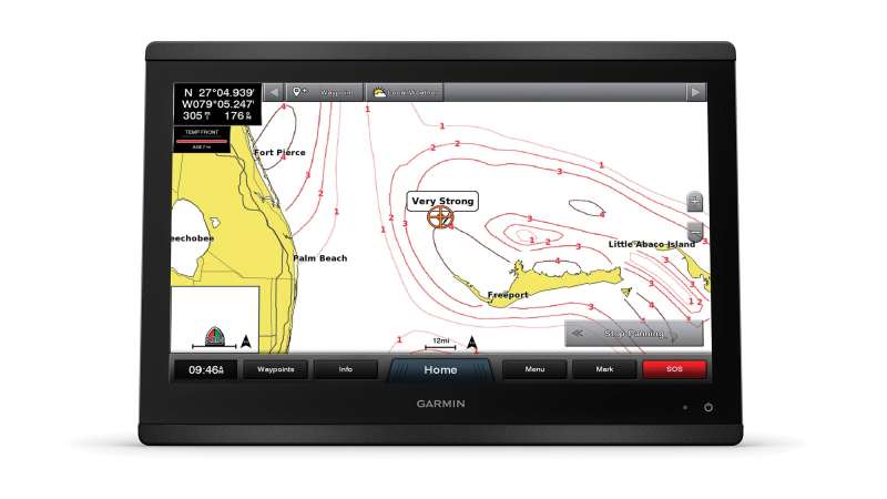
Fish Mapping’s eight data layers are: weed lines (concentrations of buoyant algae and plants), sea-surface height anomalies (areas where the sea’s surface is higher due to eddies, fronts, downwelling and upwelling), sea-surface temperature contours (contour lines that graphically depict different sea-surface temperatures), sea-surface temperature front strengths (the estimated strengths of ocean fronts), 30-meter subsurface sea temperatures (water temperatures around 100 feet below the surface), contours of plankton concentration (areas plentiful in plankton), plankton-front strengths (pairs plankton-rich areas with areas lacking plankton), and fishing recommendations (estimates for where anglers are likely to find specific species).
Each layer is displayed atop a user’s selected cartography, with the exception of fishing recommendations, which is overlaid atop cartography and any of the other seven available data layers. Only one Fish Mapping layer selection can be displayed at once (read: no quad-screen views that depict four different selections at once).
While this is a lot ofcomplex information, it’s presented in a clean and graphically engaging way with a single purpose.
Anglers “can save time and fuel by letting the technology point them to where the fish [might] be,” says Dave Dunn, Garmin’s senior director of marine sales.
While each marine-electronics manufacturers’ hardware and operating systems differ, the information is exactly the same. “There are subtle differences in the user interface, but the data is the data,” Dickerson says. These differences mainly involve each manufacturer’s choice of displayed color palettes.
As with all time-sensitive data, expiration dates matter, and SiriusXM updates Fish Mapping layers regularly. “Sea-surface temperature contours are updated every three hours, while everything else is updated daily,” Dickerson says, adding that fishing recommendations are updated Tuesday and Friday mornings (Eastern Standard Time).
While fishing recommendations are low-hanging fruit, the biweekly update rate encourages users to parse fresher data themselves. “Fishing takes place in areas of predation,” says Tim Moore, Furuno’s East Coast general manager. He suggests that new users start by examining plankton-concentration contours and plankton-front-strength layers. “Where plankton are, fish feed,” he says.
The next steps involve looking for plankton-rich areas that intersect with sea-surface temperature front strengths. “[Anglers] go right to the fishing recommendations,” Dickerson says. “But it’s not that simple. I’m cautious about the recommendations. Plankton fronts and temperature fronts are my favorites. When they overlap, it’s Christmas.”
Moore agrees: “If you’re willing to put in the time to learn all the features of Fish Mapping, you’re going to be a better fisherman.”
Users can overlay each of the eight data layers atop their choice of cartography, which ensures a familiar feel. “Fish Mapping makes it easy for anglers to see where their boat is located in relation to [their] desired fishing locations,” says Stephen Thomas, Simrad’s product director.
In addition to finding fish, the service helps anglers save fuel and time. “When we leave the dock, [anglers] each have five or six specific places in mind to fish,” Dickerson says. “Fish Mapping shows us which one will most likely be productive that day.” This predictive capability, Moore says, is especially important for commercial operations. “Charter guys will pay for anything that helps increase the chances that their clients go home happy.”
Given Fish Mapping’s price point, its flexible, no-contract subscription plans, and the fact that boaters also get SiriusXM’s Marine Offshore weather (a $60 value) with the monthly fee, the cons list is short. That said, Fish Mapping currently works only in North America, and its range is limited to 150 nautical miles from shore.
“We own our own geostationary satellites, and we only have two in use,” Dickerson says. “So [the satellite’s] footprint is the range of our coverage.”
Also, owners with satcom systems can’t use their antennas to catch Fish Mapping’s data. “The data isn’t on the internet, so it’s not possible to extend the range,” Dickerson says.
But if your angling ambitions fall within SiriusXM’s range, Fish Mapping could be an ideal tool to help land that prize species—rather than engaging in the also-ancient anglers’ art of embellishing about the ones that got away.


