ytgenewsaug6lipaper525.jpg
Since the amazing leap forward in electronic technology during the past several decades, many boaters have shelved their paper charts-and with good reason, too. The GPS and chart plotter units available today are incredibly accurate, reliable, and easy to use.
However, in my opinion, it’s still important to have a sound working knowledge of navigating with paper charts. And once that knowledge is gained, it’s key to keep your skills polished.
Although they can be a little pricey if you buy the larger regions, I like to use the Chartbooks by Maptech for coastal and inland waters. For longer passages, such as my annual trek from Florida to the Virgin Islands, I’ll go with larger charts, which allow me to plot the majority of my passage.
Regardless if it’s a week-long trek or a day-long outing, I keep a paper chart near the helm, even with a chart plotter. The primary reason is that I can reference a paper chart, in a larger scale, very quickly. I don’t have to scroll up and down looking for what lies ahead.
For example, if I’m navigating in an area with a lot of commercial traffic, I like to have as much understanding of my surroundings as possible. If a large tug and barge are turning into the channel, I can glance at a chart and in a matter of seconds determine if can cut out of the channel, giving the commercial traffic a wide berth.
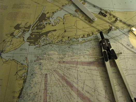
So, it’s important to know where you are on a chart, But what if you have a chart plotter that shows your position? That’s fine, but redundancy is key and comparing your position on the electronic chart with a paper chart is sound seamanship. Simply take the latitude and longitude reading from your GPS and using a straight edge and pencil, locate this on the side (latitude) and bottom (longitude) of the chart, draw the lines until they intersect, and that’s your position. (Make sure the pencil is very sharp.) Then review your position on the chart, compare it with the plotter, and you’ll feel more confident about your boat’s position.
This brings up another issue, and it may sound as if I’m contradicting myself a bit. At night or in the fog, things are often a little confusing. If I start to hesitate on my position, I go back to the pilot’s credo of always trusting your instruments. However, if you’ve been practicing on the charts in clear conditions, you’ll be more confident in reduced visibility.
Another helpful method of verifying the accuracy of your electronics, is to plot a course on a paper chart and compare this with your plotter’s COG. (We’re assuming your compass is adjusted correctly.) Take a pair of parallel rules and draw a line from your position to the point you want to go. Lay the rules alongside this track, and while keeping the alignment, move the rules across the chart to a mark on the compass rose. (I have a pair of rules from Weems and Plath with rollers that make this a much easier process.)
There are two circles in the compass rose. The outside circle represents true direction, while the inner circle shows magnetic direction. You’re concerned with aligning the rules with the inner circle in order to steer a magnetic course with your compass. In my opinion, using a compass to steer a course is the way to go rather than using a GPS. The response is more immediate. The compass is for your course, the GPS is for your position.
Another key when using paper charts is to understand the variety of chart symbols. There is a lot of useful information available to you with a quick glance. The most obvious are depth and contour lines. But knowing that dotted lines, for instance, indicate areas exposed at low tide, is helpful.
Make sure you understand the symbols for buoys and signals. These symbols indicate color, height, and sound signals. The same information is now available by highlighting a buoy on most plotters, but knowing the paper basics will make you a better navigator.