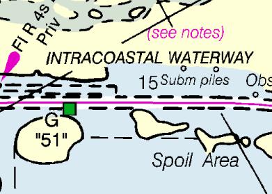
Nautical chart magenta line
Early last year, the NOAA Office of Coast Survey received complaints from boaters who said they followed the magenta line on Intracoastal Waterway charts — only to go aground or run into shoals. Now, following an investigation into those complaints, the office is changing the magenta line from the longtime “recommended route” to a new “advisory directional guide.”
“We cannot deliberately include chart features that we know may pose a danger to navigation,” according to Rear Admiral Gerd Glang, director of Coast Survey. “The problems of the magenta line’s misplacement, which had been developing over the past seven decades, were aggravated when some boaters assumed that the line indicated a precise route through safe water — although it actually went over land, shoals or obstructions.”
Fifty-two of the agency’s 1,052 nautical charts currently display the magenta line. Those with the line will be updated, and it will be added to many others, in a process expected to take three to five years.
Coast Survey also plans to add notes to all ICW charts advising mariners to watch for changing conditions and honor local aids to navigation.
Stay tuned at www.nauticalcharts.noaa.gov.