I obtained my last Loran A fix at 2355, 31 December 1980.
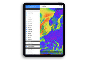
The new Garmin GPSmap 188C Sounder proves that size need not constrain capability. This diminutive waterproof unit combines a 12-channel GPS receiver/chart plotter with a dual-frequency 500-watt (RMS) depth sounder/fishfinder. The extent to which owners can customize each function and display would be outstanding in a large-screen or PC-based plotter. Finding such features in the 188C was a pleasant surprise.
Despite its relatively small size, the screen does very well in all respects, providing a clear, sharp, high-contrast image bright enough for use in an open cockpit. Equally important is the interface between the user and the device. Call it ergonomics or human engineering, the 188C is friendly.
A set of 10 single-purpose keys plus a four-way cursor button control the 188C. Garmin’s choice of single-purpose keys, as contrasted with soft keys whose functions vary depending on the program or function in use, is especially valuable for a unit operated by the helmsman. He will spend less time head-down manipulating the controls. Although the 188C is a complex and flexible device, it easily passed my try-to-use-before-reading-the-book check. On the other hand, I recommend careful exploration of the 100-page-plus instruction manual and some hours of practice to take full advantage of the unit’s many functions. The built-in simulator mode works well with the tutorial in the instruction manual.
The straightforward program logic provides immediate access to the seven display pages, the main menu pages and the menu pages associated with each of the displays. First-time initialization of the 188C took a couple of minutes, and subsequent acquisition of satellite data sufficient for 3-D navigation took less than a minute. Also quick was the power-off function, which works immediately-no built-in time delay, as is common to most devices. This instant-off may catch some users by surprise.
In chart plotter mode, the 188C consistently redrew the screen in a second or two and never exceeded three seconds. This is fast enough to make the zoom function very useful. I was able to create a screen redraw time as long as 18 seconds, but only by programming the display of all available chart information and at a scale that requires access to more than one chart file. For all normal use, screen redraw is close to instantaneous.
Centering the vessel’s position on the screen will simplify coordination of information with the radar’s vessel-centric display. The proprietary Garmin MapSource charts work about as well as any vector cartography I have used. An “unclutter command available on the first push of the Menu key when the 188C is in map mode provides an instant means for removing data. Cleaning up the display, such as erasing the soundings while leaving depth contours in place, makes the map easier to use, especially when you have selected a large-area view.
Dimensions: 6.2″ x 6.3″ x 3.7″ Display: 5″ diagonal, daylight readable, 234 x 320 pixel, 16-color TFT LCD Receiver: WAAS 12-channel Cartography: Garmin BlueChart or MapSource PC charts Output: 500 watts RMS max. Frequencies: 50/200kHz Waypoints: 3,000 Routes: 50 reversible Mounting: Flush or bracket Waterproofing: To IPX-7 standards
Sequential operation of the Pages key provides access to each of the six data pages: Map, Compass, Numbers, Highway, Active Route and Sonar. Access to the GPS data page is automatic on startup and can be manually selected from the main menu. A 17-item menu, which appears on screen with the second press of the Menu key, gives the user full access to the system’s commands. The Quit key allows the user to gracefully back out of any selection, returning to the previous choice. The Nav and Find keys provide quick access to the navigation function or to a selection of reference databases, including stored waypoints, cities, tide stations and transportation (primarily airports).
I found the Compass page particularly valuable offshore, where the chart presentation was of limited interest. A red lubber line at the 12 o’clock position marks the vessel’s current heading. The compass card rotates as in a conventional compass, but the numbers and letters remain upright, making it easy to interpret the data. When I selected a destination waypoint, a bold orange arrow and heading bug showing the direction to the waypoint appeared superimposed on the 21/4-inch diameter compass card. If I kept the orange arrow on top of the course reference, I would eventually arrive at the waypoint.
The default digital data display on the Compass page shows SOG, distance to waypoint, position (lat/lon to three decimals) and the angular difference between the required and achieved course. Each of the four primary data windows can be split into four, ultimately presenting the user with a total of 16 data items. Two strokes of the Menu key followed by a press of the Enter key restores the eminently usable four-item default display. The 188C allows nearly endless customization of each display page.
All of the fishfinder control options anglers expect were available and easy to program. Data from the sonar can be shown singly or in various formats, or can be shared with navigation information. The sonar system accepts inputs from transducers equipped with temperature and speed sensors, completing a full suite of navigation information.
The user may store a maximum of 3,000 waypoints. In addition to its lat/lon position, the waypoint can be referenced to a menu list of reference points or from any selected location. Selecting “air transportation from the menu produced a list of airports, including the NASA Shuttle Landing Facility (which was located 121.3 NM @ 067°M from our waypoint). Sailors will no doubt be comforted by the ability of the 188C to guide them back to where they started. On a more practical note, the system can organize the waypoints into as many as 50 reversible routes, each containing up to 254 waypoints. Also available is Garmin’s BackTrack feature, which automatically creates a chain of waypoints from the vessel’s recent track. I have found this feature very useful during visits to the Exuma Keys in the Bahamas.
The 188C most likely will grace the helm of many open boats, mounted on the bracket that comes with it. Removal of the plotter for safekeeping can be important in such installations, and the Garmin’s bracket excels. Unlike most of the similar units I have tested (they rely on rubber washers to keep the unit fixed at a proper angle), the mating surfaces of the 188C’s bracket and the plotter include a radial gear tooth pattern that locks in the selected viewing angle. With no washers to guide into place, installation is a snap.
Price: $1,485.
Contact: Garmin International, (913) 397-8200; www.garmin.com.
Click here to buy Garmin products.