ytgfeb19elect525.jpg
Quirky as it may sound, a major electronics highlight for me last year was using side-looking sonar technology to view the mess of granite mooring blocks and steel chains arrayed across the bottom of my harbor. Not only does my beloved Duffy 37 sit on a float that depends on this gear in heavy weather, but I sit on the town harbor committee that designed and manages the float system. My excitement, however, went well beyond subjective matters, or even practical ones.
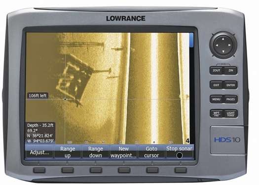
It felt like discovery as I slowly ran my test-platform skiff up and down the harbor, watching a Lowrance HDS-12 and a Hummingbird 1197C multifunction display build line-by-line images of the bottom passing below and to both sides of their respective transom-mounted transducers. I don’t believe that even the Army Corps of Engineers contractors who dredged this bottom a decade ago had the technology to see it in such detail, and I know that the divers who inspect the gear annually have to work by touch because they can’t see much. In fact, I’m not sure that anyone has seen this bottom as well as I have!
Given that above-the-surface Camden Harbor is one of the most viewed and photographed spots along the whole Maine coast, that scanning experience really brought home the truism that we’re less familiar with what’s under our own planet’s oceans than we are with the surface of the Moon. So I’m hoping that rapidly developing sonar-scanning technologies cannot only improve my cruising in practical ways, but also sate my innate curiosity.
But even the nomenclature of sonar is confusing. While the gear I tested is often called “side scanning,” it’s quite different from either the side-scanning transducer “fish” that ocean researchers tow, or the mechanically side-scanning transducers used by some high-end commercial and sportfishermen. In 2004, Humminbird (www.humminbird.com) pioneered what it calls Side Imaging, which only requires a small, inexpensive, fixed transducer, and which has earned a big following among the freshwater fishermen the company serves. Which may be why saltwater snobs like myself were skeptical. I figured that the almost photographic images of sunken boats and the like that Humminbird fans show off on the Web must have been painstakingly imaged on very still lakes.
I was wrong. The Side Imaging built into the 1197C ($2,800) consistently produced useful imagery even at 6 to 8 knots in choppy conditions, and could do it in greater depths than are usually depicted. In one morning, I got more sense of what it looks like under 100 to 300 feet of Penobscot Bay than I have from years of fishfinder viewing. Certainly the best detail is found when going slow in shallower waters, but that’s why I think this technology could be useful for, say, checking out an unknown anchorage. That’s easier now that Humminbird offers a through-hull transducer more appropriate to cruising boats, and also since Lowrance (www.lowrance.com) introduced StructureScan, a $700 black-box option to its HDS multifunction displays that seems to see sideways just as well as Side Imaging. Moreover, it seems likely that StructureScan will become an option for Simrad’s even saltier new NSE MFD series (www.simradyachtingusa.com). And Humminbird now has a saltwater relative called GeoNav (www.geonavmarine.com) that will bring a whole suite of yacht electronics to the U.S. late this year. In short, a detailed side view will soon be much easier to have at your helm.
However, there’s an obvious reason that side looking is more effective for identifying fishy bottom structure than navigation. While it may be reasonable to survey an anchorage by circling slowly, side imaging can’t help you to negotiate a narrow reef pass, let alone warn you of a semi-submerged shipping container dead ahead. Those very desirable abilities are the goal of a distinctly different set of technologies called forwardlooking sonar (FLS).
Unfortunately, it’s electronically much more difficult to take even vague underwater snap shots of the water column you’re about to pass over than it is to build detailed images of what’s gone by from narrow successive slices. Both Interphase (www.interphase-tech.com) and EchoPilot (www.echopilot.com) have manufactured cruising-boat-scaled FLS for years, but frankly the most satisfied users are those with modest expectations. It’s hard to resolve detail ahead, it’s hard to see very far ahead, and it’s hard to do either fast enough to make the information valuable. But both companies seem poised to raise their games.
At the fall boat shows, Interphase excitedly showed off Ultrascan PC90, an advancement in digital signal processing that can use the company’s existing lowprofile, fixed transducers to sample a wide swath of water column in near real time. You could wave your hand in the beam of an “air” transducer attached, and see it instantly move around the screen like a flighty school of bait. Interphase says that the system, expected to cost about $5,000, will also be useful to cruisers and will have a forward range of about 1,200 feet and depth range of 600 feet. But note that due to echoing interference, FLS is generally only able to see ahead five times the bottom depth-100 feet in 20 feet of water, for instance-which is one reason why speedy returns are important.
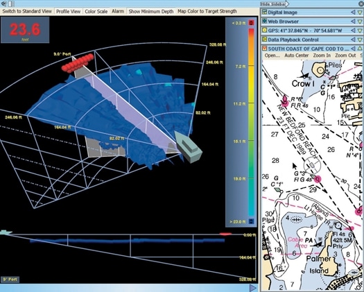
Ultrascan, like other of Interphase’s higher end FLS models, can be set to scan a 12 degree swath that’s either 90 degrees vertical or 90 degrees horizontal (with a slight downward angle), either of which is useful, but neither of which tells the whole story. EchoPilot, by contrast, has always stuck to vertical scanning and suggested that customers drive like a snake slithers if they want a wider view of what’s ahead. But EchoPilot’s new 3D FLS, still very much in prototype, can purportedly sample 60 degrees in the horizontal plane and 90 in the vertical, looking about 650 feet ahead and translating the returns into a comprehensible 3-D rendering. The screen shots taken during testing do look sensational, but it should be noted that the system involves twin retractable transducers and will cost around $10,000.
| | |
Still, neither Interphase nor EchoPilot predict that even their newer systems will reliably see a waterlogged container 1,000 feet ahead, an offshore safety milestone that is claimed by a company called Far-Sounder (www.farsounder.com) for its FS-3 FLS. Unfortunately, these systems, which also claim a range of eight times the depth and were first to draw the ping results in 3D, are scaled in price and complexity to mega-yachts and large commercial vessels. I’ll add here that it is possible to use mechanical side scanning-also expensive, but less so, and challenging to interpret- for some navigational tasks, and that was well proven by Steve and Linda Dashew during their explorations of Greenland and Scandinavia aboard Wind Horse (see “Icing on the Cake” in January 2009).
So at the moment, side-and forward-looking sonar are confusing, imperfect technologies in transition, but there are many reasons to believe the benefits will eventually be easier to obtain. And I like to think of those benefits in comparison to the maturing thermal-imaging nightvision products I wrote about last month. Those cameras can give us the very valuable ability to see in the dark like we do in the day, but advanced sonar just might give us a chance to see what we’ve never seen before.