Move your cursor over the chart to see resourse information for Block Island.
(Chart courtesty of NOAA)_ Scroll down to see the southern half of the island._
Last month we arrived in Cape May, New Jersey, after leaving our home port of Annapolis, Maryland, for a one-year, East Coast virtual cruise. Spending a couple of days in Cape May gives us time to enjoy the local boating and beach scenes while we prepare for our offshore run to Block Island, Rhode Island — a distance of 210 nautical miles.
We’ll be checking the weather reports carefully, since we’ll be about 90 miles from land halfway through this ocean passage. If we don’t see a clear 24-hour weather window, then we can always change plans and hug the Jersey coast for the 125-nauticalmile run up to Sandy Hook, New Jersey. From there we could take a tour of New York Harbor, run up the East River to the Long Island Sound and continue east past Montauk, eventually arriving at Block Island, Rhode Island (See page 2). This 270-nautical-mile alternative route could take two to three days.
But the weather report looks perfect, and with our cruising speed of 18 knots, we can make the entire ocean passage in daylight. The day before we head out, we’ll fuel up and do a thorough inspection of our engine room. Fuel filters are changed, if necessary. Engine and transmission oil levels are checked, and belts are inspected for wear and proper tension. We also make sure we have extra oil on board.
Before the beginning of our voyage, we had our life raft serviced and repacked, and we’ll now doublecheck our man-overboard (MOB) gear, including our life ring and lifting harness. We’ll also review our MOB drill with our crew and notify a relative of our float plan. The anticipation of an offshore passage always gets our adrenalin running, and even after years of making similar trips, we’ve learned never to get too confident or complacent.
We begin to feel our boat rise and fall to the gentle ocean swells as we head out of the inlet at first light. Once we round sea buoy “F,” we program our vessel’s autopilot to take us to our first waypoint off Montauk Point, a heading of 58° (magnetic) for the next 187 miles. Besides a few fishing trawlers and an occasional sport-fish yacht heading out to the canyons, we’re alone on the ocean. The throaty sound of our reliable diesel engine and reassuring, yet repetitive, weather report on our VHF drown out the natural sounds of the sea rushing past our craft’s hull. We feel that sense of freedom coupled with anxiety that all offshore passages seem to bring. It is very good to be at sea again.
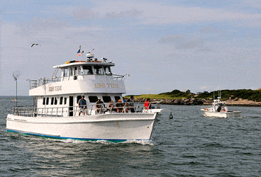
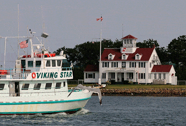
Less than 11 hours after leaving Cape May, we’re passing Montauk Point and now head directly to the R “2” buoy off the entrance to Block Island’s New Harbor and Great Salt Pond. With just 13 miles to go, we’ll be there well before dark and in time for an early dinner. As we enter the harbor and pass the picturesque Coast Guard station, we get our first whiff of the salty New England sea air.
We’ve planned our arrival to be during the week, because Block Island weekends can be overly crowded, if not a bit crazy. (The harbor master has estimated that as many as 1,500 to 1,800 boats have visited here on a busy weekend.) The town maintains 90 moorings at a cost of $40 per night, and there are three marinas in Great Salt Pond that provide transient slips. But on weekends, a slip may be nothing more than being rafted up to several other boats.
While the anchorage is spacious, getting the hook to hold in the 20- to 50-foot depths can be challenging, and we’ve witnessed boats dragging from one end of the Pond to the other in a heavy blow. Since we have a shallow-draft craft, we’ll drop our hook in the southeastern corner just outside a private mooring field in five to six feet of water. Once set, we’ll call the family member that has our float plan and let him know we’ve arrived safely.
Launch service is available by calling Channel 68, but we land our dinghy on the small rocky beach near Dead Eye Dick’s restaurant, one of our favorite haunts. Before we head to the eatery, we’ll walk over to Payne’s Dock and deposit our 50-cents-per-person landing fee in the collection box, which is good for our entire stay. As usual, Dick’s food is great and the waterfront view is even better. We’ll head back to our boat after dinner and prepare for an early morning, because there is a lot to see on this charming island, sometimes described as “the last great place.”
We awaken the next morning to the iconic sound of a distant voice crying out, “Andiamo, andiamooooo!” It’s the morning wake-up call from Aldo’s pastry boat, which for the past 40 years has been delivering hot coffee, baked goods and breakfast sandwiches to boats on the Pond. After coffee and pastry on board, we’ll take the tender to the designated dinghy dock on the west side of hamplin’s Marina, where we’ll rent a couple of bikes and begin our exploration of the island.
A ride to the Southeast Lighthouse is a good way to start the day. Originally built in 1874, the lighthouse was moved back 360 feet because of erosion to the bluff on which it was built. (We visited in 1993 when it was being moved, and we remember being in awe that workers could move such a massive structure.) A museum on-site features a display of the original Fresnel lens, supposedly worth millions of dollars.
The island is just three miles wide and seven miles long, but it boasts 17 miles of beaches. There’s a joke that, when visitors ask locals how to get to the beach, they reply, “Just start walking in any direction.” From the lighthouse we’ll backtrack and head to Crescent Beach, the 2 1/2-mile stretch of ocean beach just south of Old Harbor and the town of New Shoreham. The old-fashioned Town Beach pavilion provides beachcombers with chairs, umbrellas and cabanas as well as shower and restroom facilities.
A walk along New Shoreham’s Water Street will take us past Old Harbor, where the ferry service to Point Judith, Providence, Newport and New London is located. Anchoring in the basin is limited, but there are slips available at the town dock for $2.50 per foot.
We’ll browse the various shops and galleries, stopping at the always different and quirky Glass Onion, which was founded by a New York fashion photographer turned landscape contractor. It’s tiny and overflowing with an eclectic collection of apparel, books, jewelry and other miscellanea. Before heading back to our boat, it’s time for a quick tour of the historic National Hotel with its impressive, wraparound porch overlooking Old Harbor. Then we’ll treat ourselves to a lobster roll at the nearby Harbor Grill.
During our bike ride, we won’t see fastfood outlets or chain stores, and there will be only one gas station and grocery store. Most establishments are small, family-owned businesses catering to summer tourists who come here for the hiking, biking, fishing, beaches and just plain relaxing. Indeed, it has been said by locals that “the best thing to do on Block Island is absolutely nothing.”
(Chart courtesty of NOAA)
A Side Trip to Eastern Long island
Come with us as we explore five of our favorite destinations located between the fish tail of Eastern Long Island.
**
**
Montauk, New York 41° 2′ 18″ N 71° 57′ 2″ W
Before we continue north from Block Island, we’ll take a few days to explore both forks of Eastern Long Island starting with a 17-mile run to Montauk, known for its great sport fishing. We’ll be sure to check the weather, as Block Island Sound, which is exposed to the Atlantic Ocean, can be a very rough body of water. The channel leading into Montauk Harbor is well marked and protected by lighted jetties, but it can be a busy thoroughfare with charter boats, head boats and sport fishing yachts coming and going. We’ll head directly to Star Island Yacht Club and Marina for a slip. Dinner at Gosman’s, a ten minute walk from the marina, never disappoints. The next day we’ll rent bikes and ride to “downtown” Montauk for some re-provisioning at the local IGA store.
**
**
Sag Harbor 40°59′48″N 72°17′32″ W
Heading west, we’ll hug the South Fork for a 25-mile run to Sag Harbor, being careful to stay clear of the shoals south of Gardiner’s Island. Since we plan on only staying one night, and the weather forecast is for light and variable wind, we’ll drop our hook outside the breakwater to the east in 10-feet of water. We take our dinghy to the town dock and stop at the visitor’s center in the windmill building to get directions to the Whaling & Historical Museum. Here we learn of Sag Harbor’s rich history as a whaling town. It was even mentioned in Moby-Dick. Walking back to town we’ll check out the inner harbor beyond the fixed 21-foot bridge where a number of marinas are located. We’ll then top off our day with dinner and a spectacular harbor view at B. Smith’s.
**
**
Cutchogue 41°00’00”N 72° 28′ 08” W
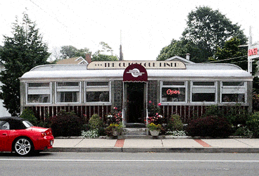
Since I spent my summers here as a child, we’ve come back to see how much things have changed. The good news, like most of Eastern Long Island, is that much is the same. Cutchogue Harbor, a narrow cut off Little Peconic Bay, features a small marina, now owned by the New Suffolk Shipyard nearby. Clean, neat and cozy, it has a fuel dock, laundry, restrooms and showers. I can still remember swimming off the docks as a kid and am delighted to see that my grandfather’s home across the street looks as good as it did in the 50s. We meet a local couple and ask them if the Cutchogue Diner, two miles from here, still exists, and they offer us a ride there in the morning for breakfast. After a hearty morning meal the next day, we take a stroll along Main Road and return to the marina to continue our exploration of Eastern Long Island.
Shelter Island 41° 4′ 41″ N, 72° 21′ 3″ W
Located between Long Island’s fish tail, Shelter Island offers four protected anchorages and a few small marinas. Because the only access to the island is by private boat or ferry from Greenport or Sag Harbor, it has remained largely unspoiled. We’ll pick up a mooring in Dering Harbor on the island’s northwest corner (managed by Dering Harbor Marina) and take a walk along Bridge Street, being sure to visit Bliss’ Department Store, a tiny store that has a little bit of everything. A walk up the hill brings us to the Chequit Inn for lunch. Across the Island in Coecles Harbor is the Coecles Harbor Boatyard where the beautiful 38-foot Shelter Island Runabout, conceived by Billy Joel, is built. The sandy beach of West Neck Harbor is worth visiting, but the entrance can be tricky. Keep the red nun “2” to starboard, the beachhead to port and then stay closer to the beach on your port side as you enter the basin.
Greenport 41° 06′ 12″ N 72° 21′ 33″ W
From Dering Harbor we can see busy Greenport, a mile away on the North Fork. We’ll get a slip at Sterling Harbor Marina, which has fuel, floating docks, well-groomed grounds, a pool, laundry and a full service yard. A 15-minute walk into town brings us to Preston’s, one of our all time favorite chandleries. (The marina also offers a courtesy shuttle into town.) The 1920s carousel in Mitchell Park is still in operation, and the East End Seaport Marine Museum offers exhibitions for all ages. Happily, this old whaling town is thriving after years of being in decline. Shops, galleries and restaurants are busy, and the marinas are nearly full. We can’t resist a visit to good old Claudio’s Restaurant, which has been here for over 140-years. Grabbing a seat at its famous bar, we’ll enjoy a dozen Peconic Bay cherrystone clams on the half shell and a cold brew. Tomorrow it’s off to Cape Cod and more points north.