3-D Chart Plotting
Three-dimensional charting may be the multifunction display feature seen the most in advertisements but used the least in the real world. In fact, a surprising number of generally knowledgeable navigators who post comments on my blog dismiss it as a marketing gimmick. But while it’s true the early versions of 3-D weren’t good for much more than trying to impress your marina mates, I believe that most of the MFD manufacturers have developed their 3-D presentations to the point where you ought to give them a serious try — even if it means reexamining the way you’ve always navigated!
Whether you learned marine navigation from a course or on a parent’s knee, 50 years ago or last summer, the lessons almost undoubtedly centered on paper charts. And for most of the short history of electronic charting, the goal was to duplicate digitally the informationrich paper chart over which your boat was constantly plotted. As that goal was pretty well accomplished, and much appreciated, along came optional overlays such as photo maps, points of interest, radar, weather and AIS. Though often pooh-poohed at first, all of those features are well-liked by many boaters today.
Navigation has changed a lot. But for most practitioners it’s all happened within the constraints of a traditional top-down, twodimensional chart view that, in truth, is more about the limitations of the printing press than what’s ideal when you’re trying to work your way through hazardous waters.
What makes 3-D charting unprintable is that your display computes an ever-changing point of view (POV) unique to your boat’s location and heading. The typical bird’s-eye image puts you several hundred feet above the helm, and slightly behind it, looking forward at charted information and overlays that have been shaped and shaded with bathymetric and topographic information to simulate how they might really look, though augmented in ways meant to help you avoid mishaps. Underwater dangers may be brightly color-coded, or lit navaids may graphically indicate their color and pattern so you can confirm them against reality without having to read their characteristics. The vessel-centered look-ahead POV means you get to see more detail immediately around you, where you need it, without losing a sense of what’s coming up, as though you were viewing two or more zoom levels or chart scales at once.
Perhaps most important, though, is the way 3-D makes chart and overlay data more naturally correlate with what you’re actually seeing from your helm as you move through the water, so that it’s easier to make the correct connections. However, it’s fairly freaky how different 3-D is from the conventional 2-D view, and I know numerous boaters who’ve tried it just once, at a dock. That’s a mistake, because 3-D really shines when under way, while 2-D does remain the sensible mode in which to plan a voyage when tied up. A north-up, top-down view lets you look around a chart without losing overall orientation, and no one particular spot needs your bird’s-eye focus until you’re moving. In practice, creating a route over a traditional chart view, and then running it in 3-D, can go together like lobster and butter. That’s why adjusting a route in 2-D but driving it in 3-D is standard operating procedure when it comes to electronic automobile navigation. It’s just that when you climb into your car, you don’t have to overcome centuries of powerful tradition to look at a 3-D map.
This summer I tussled with my own decades of navigation habits by using 3-D views on four different multifunction displays, and I’ll be testing the feature in PC charting programs before winter closes in (all discussed in more detail on my blog). I am by no means a total convert, but 3-D is certainly not just a marketing gimmick. I believe that the manufacturers are working hard to perfect 3-D navigation because they’re convinced that it will become highly desirable for underway route-running — once we open our minds to it — and I think they’re right. But the jury is certainly out on what 3-D perfection looks like.
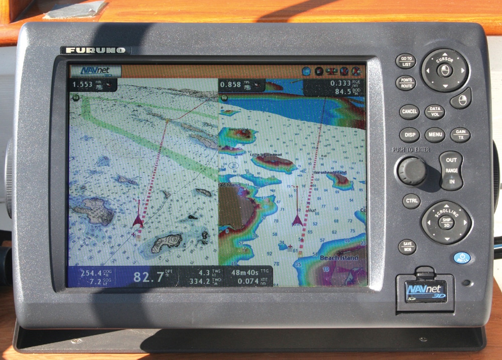
In classic and successful Garmin (garmin.com) keep-it-simple-but-easy fashion, the company’s various multifunction displays permit only limited zooming in 3-D; the view becomes familiar quicker, and without confusion, but there are situations in which I’d like more 3-D scale control. In classic and successful Furuno ( furunousa.com) high-performance-but-manual-required fashion, NavNet 3D gives you unlimited zooming, scrolling and tilting and even lets you fly around in 3-D mode, but you may get giddy.
And the truth of those stereotypes goes only so far. There’s an elegance to the way Furuno simply morphs its 2-D into 3-D, with all details and functions intact and a single button-push that easily switches back and forth. Garmin treats 3-D as a separate function window, like fish-finding, and disables some regular charting tasks, like selecting mini automatic radar plotting aid (MARPA) targets. On the other hand, a Garmin user with a g2 Vision chart card now gets a choice of three distinctly different mariner 3-D modes, acknowledging, I think, that a perfect mode is not only elusive, but also subjective.
The Raymarine E-Series Widescreen (raymarine.com) and Simrad NSE (simradyachting.com), on which I’m also testing 3-D, both need a Navionics platinum chart card to display it, and it’s interesting how very differently they currently derive 3-D from the same data. There’s tremendous nuance to all the shading, scaling and data choices possible, as well as screen options and controls. The NSE works for me, clearly imparting critical information both near and far, while the Raymarine needs work. But Raymarine knows that and is promising many refinements in a software update coming soon.
There are infinite ways to render and augment 3-D charting. For instance, Furuno and Garmin seem to be using the fast-heading and even roll-motion data available on many modern systems to animate the 3-D icon representing your own boat. Some navigators find this irritating, but it speaks to the deep visceral change manufacturers are trying to enable. If an electronic chart display can connect solidly to your gut boat sense and the dangers in its path, maybe you can save some brain cycles from the normally intellectual task of chart interpretation — brain cycles you can use to look for uncharted dangers, or just to enjoy yourself. The 3-D screens that so many dismiss as confusing or gimmicky may, in fact, be the screens that demand less attention because they deliver the information better.
But old habits die hard. I’m quite aware that I’m tapping out this article using a “qwerty” keyboard layout designed more than a century ago to slow my typing so that the mechanical type levers that went away in my distant youth won’t jam! That’s why a cursory look at 3-D charting usually doesn’t work.
Instead, lay out a route in the traditional fashion, preferably in a familiar area, and once you’re under way, put at least half the navigation display in 3-D mode. Stick with it, and see if your internal navigator doesn’t start intuiting information off that screen in new ways. For instance, at first I had no use for a 3-D display that didn’t include the spot soundings I’ve always had within sight when cruising the opaque and unforgiving waters of Maine. But now I’m experimenting with a clean, colored bathy-contour 3-D view and wondering if all those depth numbers weren’t a wicked waste of synapses. The tried-and-true way is not necessarily the most natural and relaxed way. Perhaps it’s time to open our minds to another dimension.