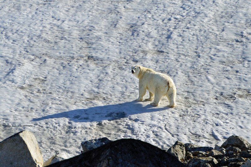
While we’ve seen countless bear tracks, we have yet to encounter a bear. In Svalbard, the archipelago between Norway and the North Pole, polar bears are so prevalent and pose such a threat to humans that it’s mandatory for each shore party to carry a firearm. We watch from the safety of the 68-foot Nordhavn Migration one sun-drenched day as a sailing vessel makes an abrupt 180-degree turn. Through binoculars, we see the swimming polar bear the vessel is working hard to avoid. I grab my cameras and, with two companions, motor out in the tender to follow the bear from a safe distance. He pays little mind other than to glance over his shoulder occasionally at us with profound indifference. Dog paddling, the bear makes his way to the far shore, shakes off in canine fashion and ambles up a rocky bluff to a snow field, where he promptly falls onto his back and rolls with all four paws reaching skyward. We’re so giddy that we nearly forget he’s among the greatest of all apex predators.
Getting to this moment has been a memorable adventure. I’ve made many ocean passages, all too often across unfriendly seas, but somehow this one is different. Each time Migration’s bow digs into a trough, she feels as if she’s come to a standstill, protesting the notion of going any farther. I know exactly how she feels; I’m prone to seasickness, however, I’ve made an uneasy truce with the malady, learning to live with it rather than fight it, while cursing those who are immune. This first leg, from Tromsø on Norway’s northern coast to the Svalbard Archipelago, is a clear indication that hostilities have resumed.
After 43 hours and 256 nautical miles underway, we make landfall at Bear Island, roughly the two-thirds mark between Norway and Svalbard. The passage is characterized by 8- to 12-foot waves with a miserable short period, and a steady 25-knot refrigerated northerly on the nose. We seek shelter in a lee called Sørhamna (hamna means harbor in Norwegian, but this is little more than an indentation in a lee). I follow the lead of Migration’s owners, George and Marci, along with their 12-year-old Goldendoodle — whose sea legs are better than mine — in taking hot showers and eating a meal for the first time in almost two days.
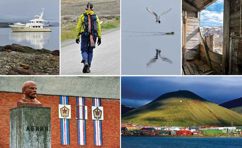
It’s foggy and cold, at 37 degrees Fahrenheit. Determined to get some fresh air, we launch our smaller RIB and cruise the shoreline, motoring along cliffs festooned with nesting fulmars and puffins. The water around us is rich with bobbing birds. Some swim right up to us.
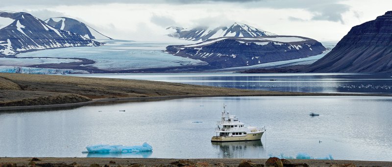
A weather window beckons, so we weigh anchor and are underway after just a few hours. A full day of steaming brings us to Sørkappøya, an island just off Svalbard’s southernmost shore. It’s a welcome sight. Mercifully, the conditions for this run were better, but the last few hours saw winds up to nearly 50 knots, with seas churning and, at times, visibility of just a few hundred yards in mist and spume. Waves broke over Migration’s bow and pelted the windscreen. Now, in the lee of Svalbard’s Vesle Svartkuven peninsula, conditions have improved, but there’s no doubt that we are in the maw of the frozen north.
Planning for this voyage was a year in the making, and during that time, with few exceptions, when I mentioned to anyone my intended destination, the invariable first reaction was, “Where’s that?” quickly followed by, “Why would you want to go there?”
To quote George Mallory, because it’s there.
The polar ice pack is farther north than usual, and George is making a run north to “the edge.” Using a satellite ice report from the research station in Ny-Ålesund, we establish a waypoint and begin our trek north. Six hours later, we are in what British explorer Henry Worsley called “the milk.” In all directions, a pewter sky meets a slate-gray sea. We’ve gone off the chart, literally; on our present heading, save the ice, there’s nothing between us and Alaska except the pole. The magnetic compass reads 335 degrees, while the true heading is 44 degrees — a variation of a staggering 69 degrees, a function of our proximity to the magnetic north, rather than geographic, pole.
Eleven hours after getting underway, I’m beginning to wonder if this was worth it. We are eating up valuable time around the archipelago to see mile after mile of featureless sea surface.
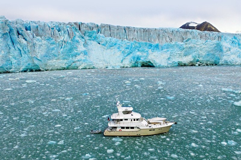
Then we begin to encounter ice. While ice is nothing new for Migration (she’s cruised amid it in Newfoundland, Greenland and Iceland), this is the polar ice cap. As the ice becomes thicker, we find ourselves changing course to search for leads that will take us north. Finally, after 13 hours, we reach a point where it’s deemed too risky to go on; getting beset in the ice isn’t the kind of Shackleton-esque adventure we’re in search of.
I snap a photo of the GPS, 81°27.7, for proof. We are just 500 nautical miles from the pole.
We drop the anchor onto an ice floe, launch the drone for some aerial photos, take a group shot on the foredeck (because it’s that much farther north) and then turn our bow southward.
To the best of my knowledge, we are now the record holders for the farthest north production motoryacht voyage.
Back in the USSR
Coal and mining run through the fabric of Svalbard like an obsidian thread. Mines have opened and closed as the world fought wars, endured depressions and undertook revolutions. Coal mining is thankless, dangerous work even under the best of circumstances, and the Arctic serves up anything but favorable conditions. Most of the coal seams in Svalbard border on the edge of profitability, and many are relatively thin, which means much of the coal needs to be dug by hand.
Located adjacent to the Nordenskiöldbreen glacier, the Russian coal mine of Pyramiden was established prior to World War II. The original buildings were little more than log cabins, some of which still stand. The mine was productive; however, the fjord is frozen for much of the year, making it difficult and costly to ship coal. That challenge, along with the dissolution of the Soviet Union, spelled the mine’s demise. The last workers and their families bid it farewell in 1998.
Today, piles of once-productive machinery, conveyors and cranes are rusting into oblivion, surrounded by imagery of hammers, sickles, red stars and other Soviet imagery. The place is an explorable, Soviet-era ghost town where former workers’ apartments serve as a hotel.
From the Logbook
Virgohamna, North Danskøya, 79°43N latitude is enveloped in fog. We drop anchor 200 yards from a tiny, rocky island. Special permission, which we have, must be obtained to visit this site because it’s rich with archaeological remnants from two historic North Pole expeditions: Salomon August Andrée’s Swedish 1896-97 balloon, and Walter Wellman’s 1906, ’07 and ’09 U.S. zeppelin launches. Andrée and his fellow balloonists crashed here and managed to make it to one of Svalbard’s far northeastern islands, Kvitøya, where they perished, it is believed, from eating undercooked, trichinosis-infected polar bear meat.
As a boy, I was enthralled reading about Andrée’s expedition, learning how his team made hydrogen for the balloon on-site by pouring sulfuric acid onto iron filings. On this day, I walk amid these very filings and the remains of the ceramic “still” used to make the lighter-than-air gas used for the ill-fated balloon.
Svalbard
Svalbard, Norwegian for “cold coast” or “cold shores,” is also known by its former Dutch name, Spitzbergen, which also is an apt title, meaning “sharp mountains” or “pointed mountains.” The archipelago is roughly midway between Norway and the North Pole.
Other than tourist charters, we encountered no other cruising vessels during our visit. Svalbard belongs to and is administered by Norway, although other countries are permitted to, and have, established settlements and commercial concerns here. No visa is needed to visit, and anyone can work without permits. Technically, while part of Norway, Svalbard is not part of the European Union.


