A sea trial is the moment of truth for any newly launched yacht. All the computerized modeling and test scenarios can give an indication of real-world performance, but it’s the challenges of the real world that prove the point. The same goes for any equipment on that yacht, particularly electronics, where the lab is particularly cushy and climate-controlled. My initial report on the Furuno NavNet 3D electronic multifunction navigation and information system, published at the time of its rollout at the Ft. Lauderdale show last October, was necessarily based on using the system in a laboratory environment at Furuno’s U.S. headquarters in Camus, Washington, since production gear suitable for normal on-water use would not be available until early this year. In that environment, the NavNet 3D seemed nothing short of revolutionary.
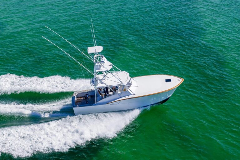
But NavNet 3D products are now reaching dealers and boat owners, so I figured I’d see how they work on the water. Our sea trial on a Regulator 26 covered 66 nautical miles in waters off Massachusetts between Hyannis Port, Buzzards Bay, Robinsons Hole, and Vineyard Sound. Weather conditions were ideal, bright to occasionally hazy sun that provided a good viewing test for the LCD screens and a light chop that, at speeds over 20 knots, delivered some of the boat motion needed for evaluation of the operability of the NavNet 3D systems controls. The bottom line, after five hours of using and watching others work with all of the components and functions of the system: It’s even more impressive than I was able to appreciate from the laboratory evaluation. Here’s why.
As we left the dock the initial chart display was a vertical oblique, two-dimensional view of a familiar raster navigation chart (RNC). Both the 8.4- and 12.1-inch LCD displays provided sharp, clear images that were easy to read, even at a considerable distance. Five people were on board for the test and huddled at the helm, so there were times when viewing distance was in excess of six feet.
We examined various chart views as we proceeded toward Woods Hole. Switching from the initial two-dimensional image to a three-dimensional view, the image initially provided a viewing perspective from above and slightly behind the boat. The RotoKey controller was turned to vary the “look” angle (1- to 90-degree apparent altitude), then pushed to confirm the setting and rotated to vary the viewpoint position around the azimuth circle.
The system’s TimeZero display technology allowed us to pan across and zoom the chart image without the annoying screen redraw pause we find in the other chart plotters we have used. If you have not had an opportunity to see the on-screen benefit of Furuno’s TimeZero display technology, a look at Google Earth will provide a useful preview.
The value of the NN3D’s three-dimensional presentation became particularly clear as we approached the east entrance to Woods Hole. I have sailed these waters many times during the past 35 years but have until now been able to fully appreciate the overall navigation situation from a small plane, never before from a boat. Selecting the system’s Satellite Fusion option immediately overlaid the adjacent land areas with satellite images that included shaded submerged land detail along the shorelines. The satellite view and later the bathymetric chart image of the area were precisely matched to the chart. The three-dimensional chart image provided by the NavNet 3D system is the first I have seen that I believe will be really useful for real-time navigation rather than solely as a navigation planning tool.
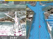
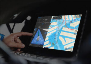
| |SPLITTING HAIRS. Charting packages let the NavNet 3D user take advantage of satellite imagery and multiple views, while lag-free redraw-even on a split screen-keeps the information flowing.|
In the Woods Hole area we switched the chart view from the familiar RNC image to the electronic navigation chart (ENC) “cell” of the area. Although the ENC was clear and easy to read, we preferred the RNC image. Although using the ENC allows access to all the information stored within its digital database. We think it is safe to assume that NavNet 3D will offer an overlay of RNC on ENC at some future time, presenting the navigator with the best of both technologies.
We turned on the radar, and the display immediately showed an image free of sea clutter. The image was derived from the information being captured by its rapidly spinning antenna: 48 rpm at the short range at which it was operating, automatically adjusted to 36 or 24 rpm at longer ranges to accommodate the longer pulse lengths required for optimum performance. All radar-operating adjustments were made automatically by the control algorithms in its digital processor. There was no need to access any of the radar controls other than the offset, range, dual-range and ARPA (automatic radar plotting aid) functions.
The performance of the DRS4A, 4 kW Ultra High Definition radar ($4,600) is superior to any previous Furuno marine radar I have used. The sea was reasonably calm but active enough to have produced some sea clutter on the Furuno radar on my boat.
The NN3D’s UHD digital radar picture was completely clear of clutter and showed excellent suppression of the initial bang. The radar produced clear images of small seabirds that were flying only a meter or so above the water. The radar could scan each range with its optimum pulse length simultaneously, which was evident in the quality of the on-screen radar images.
Radar returns from other small targets were equally impressive. Images of large, highly reflective targets including buildings and a NOAA survey ship docked in Woods Hole were sharp, clearly defined and stable as we maneuvered nearby. After reentering Vineyard Sound from Buzzards Bay via Robinsons Hole, we activated the radar’s ARPA and set a guard zone. A few minutes later an alert tone announced the presence of a radar image in the guard zone. It was a bird, and the ARPA acquired the target promptly.
AIS signals from commercial vessels were received and their positions displayed on the screen, along with their MMSIs. After a few minutes, we were able to view detailed information of the commercial vessels on the screen, since their AIS units had transmitted their full identity messages. The ability to correlate a radar image with an AIS target is a major step in reducing uncertainty and risk of accident, especially in poor visibility in heavily trafficked areas.
Overlaying radar on a chart can provide valuable navigation information, provided the radar image, necessarily referenced to the boat, always remains accurately aligned with the chart. The presence of two electronic heading sensors, the gyro-aided flux gate in the PG500R and the two-antenna SC30 Satellite Compass, provided a unique opportunity to judge the relative contribution of two different heading-sensor systems in delivering a useful radar overlay image.
The gyro-stabilized magnetic flux detector sensor, the type most often used, delivered what we judged to be acceptable overlay performance. Then we switched the system to use the GPS compass as the heading data source, which kept the chart and radar in precise alignment regardless of how the boat was maneuvered. The precise, fast-response true-north-referenced heading information from the satellite compass also enables the radar’s true motion target trail display mode, greatly benefiting radar target analysis and simplifying navigation in crowded waters. But there’s more to the SC30 than even this obvious benefit.
We explored the functionality of both them 12.1-inch MU120C display ($4,995) and the 8.4-inch MFD8 screen unit ($3,195), paying attention to the use of the system’s RotoKey. While the NN3D control panels may appear “busy” at first glance-there are two four-way cursor pads in addition to the RotoKey, each with a central key and a range-control toggle switch, and 10 other keys-the logic of the design makes it easy to learn. Most of the control keys operate as “toggles,” press once to execute a command, press again to back out.
RotoKey is simple to use, as with many similar controls, such as that of the iPod, you soon wonder why you have gone so long without it. The control is rotated to display the “soft control” choices: You can preset the number to be displayed, basic, standard, or full.
Learning time for the NavNet 3D’s control system is remarkably short. To create and modify chart plotter routes, the user sets navigation points and routes created using the cursor control and a stroke of a key. The system also provides a “Flyover” feature that animates a stored route, presenting an overhead 3-D view as the on-screen vessel icon makes the simulated voyage. Any error in routing, such as choosing a path across land or under a low bridge will be immediately, and embarrassingly, apparent.
Most captains experienced with multifunction navigation equipment will be able to operate the system in its basic modes within a few hours. The promise of the Furuno NavNet 3D system has been more than fulfilled. The system does what was advertised and, based on our sea trial, a lot more besides.

More Than True North ******Compensating for the ups and downs of yachting.**The SC 30 Satellite Compass ($2,495) also enables a valuable operating mode in the DFF1 network sounder, by continuously measuring the boat’s roll and pitch angle and using a three-axis rate gyro and accelerometer to track the vertical motion, the “heaving” of the boat. The vertical height information is used by the DFF1’s Heaving Compensation system to remove errors in sonar depth information caused by boat motion. Ordinarily, the motion would normally be observed as false and undetectable variation in the configuration of the seabed. On our trial, although the seas in which we were running were slight, the change in bottom image that resulted when the Heaving Compensation system was turned on was obvious. In addition to presenting a more accurate image of the seabed, the system may make it unnecessary to use the fishfinder’s bottom-lock mode, improving visualization of fish targets close to the seabed. The roll and pitch information from the satellite compass can also be used to stabilize the image produced by a Furuno searchlight sonar.|
Furuno USA, www.furunousa.com, (360) 834-9300