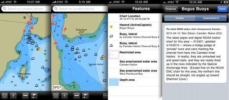
Pardon me if I use an entry on the improving state of marine iPhone apps to illustrate my concerns about NOAA’s local chart screw ups, but it works (I think). Navimatics Charts&Tides 3.6.2 was the first charting program of any sort I’ve seen that includes NOAA’s first 1:20,000 ENC for Camden Harbor, but it will be confusing fog bound visitors soon! Those semi-invented channel buoys that I first saw on the raster chart are worse here, given equal graphic weight with real navigation aids, more precise looking wrong locations, and all without the “Priv aids” label that might help a navigator sort things out…
This is not Navimatics’ fault at all; a chart update to Coastal Explorer gave me another view of the new ENC, and it looks essentially the same. Yes, they are labeled “Camden Harbor Buoys…” but that’s not the same as “Priv aids.” Of course a saving grace for both CE and C&T is that they can both also display Active Captain info, so someone like me can warn others about the confusion. Tapping for more data info is much improved in this latest version of Charts&Tides, by the way, and the ability to turn the chart seems easier and hence more useful.
But before I get into a few more marine apps improvements I’m seeing, I have more to say about ENCs. In this new one of Camden, for instance, NOAA has added a lot of detail about the piers and float systems in the Inner Harbor, which would be neat except that they made many mistakes. Then there’s my further research into those those “cribs” on the Kennebec River, a danger pretty well charted on paper and RNC, but de-emphasized in the ENC format, a de-emphasis often copied by the private chart makers. I’m really beginning to wonder about the ENC process, and hope you all will be on the lookout for dangers that aren’t well displayed on them, or other oddities (and please take screen shots). All of which is rather ironic today as I stumbled onto a newsgroup thread in which several boaters are ranting about the danger of using anything but “official” navigation data.
Well, balderdash; I’m sure NOAA and other HO’s are very well intentioned, but I’ll use every bit of data I can find to better understand where I am and what I’m getting into with my vessel. That’s why inexpensive smart phone apps that can show the most updated charts, perhaps in a format you don’t have otherwise, and optional data, are great. And also why I’m delighted to report that the new new Navionics Mobile beta app includes the panoramic port photos normally only seen on their high end card packages, like the Camden Harbor aerial shot below left. I hesitate to even mention a new all-in-one Navionics app, as the first take I previewed never made it out of beta, but the latest design is even better, and I’m told it will be real soon.
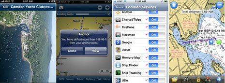
I was also pleased to see how quickly Memory Map picked up the latest local raster chart, below right, and how easy its waypoint/route making tools have gotten. And, yee-ha, note that there’s a new Anchors Away iPhone anchor alarm program out and thanks to its OS4 awareness, it can do its thing in the background. I’m hoping that all the iPhone charting apps will be able to track in the background eventually (like Android apps can ;-), and there are several interesting new non-charting iPhone apps I’ve been meaning to write about. More soon.
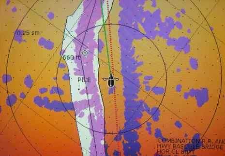
PS In response to my chart issue request, “Sherri & Nick & Sweet Time” sent this radar overlay screen shot of the ICW between Charleston and Georgetown, SC. They said it looked the same on a PC with ENC and RNC charts. Of course their observations about where the land is, and where the water isn’t, are not official (see comments).