ytgmar29cy525.jpg
I grew up on Long Island and have spent a good part of my lifetime cruising the Atlantic Coast. I thought I had seen a lot of rough water-heck, I even went down in a ferocious Gulf Stream storm while attempting to sail to Bermuda and had to be rescued by a supertanker.
So when I reached Lake Huron during our family’s one-year Great Loop cruise aboard my trusted Thomas Point 43, Sawdust, I was looking forward to my first season of cruising the Great Lakes, where I could relax and enjoy the natural surroundings. After all, lake waters are as smooth as a mirror, right?
I soon learned two things about the Great Lakes. First, they offer some of the most pristine waterways and spectacular scenery I have ever experienced. Second, these waters can create absolute havoc, quickly.
Working our way west from New York and the Canadian inland waterways, we entered Georgian Bay, a 200- by 50-mile body of water that is part of Lake Huron. Leaving the protection of the Trent-Severn Waterway, one immediately switches to a heightened level of awareness because of the forbidding navigational hazards. The route to open water, as you exit Port Severn, is through narrow Potato Island Channel-undoubtedly named for the hundreds of large, potato-shaped rocks at or just below the surface. While Canadian strip charts are accurate, there is no room for error. And if you hit bottom in this part of the world, it’s going be hard.
Georgian Bay is known for its 30,000 islands and hundreds of scenic anchorages along the 175-mile route between Port Severn and the village of Killarney. Like most cruisers, we anchored out, exploring uninhabited islands by day and enjoying star-filled skies and a warm fire by night. While much of this route is protected, there are areas that require sticking your nose out into open water. You need to keep an eye on the weather and make sure you’ve charted a safe course for entering your next anchorage.
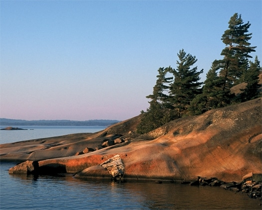
Continuing west, we left Georgian Bay to explore the North Channel, which separates the 1,000-square-mile Manitoulin Island from the shores of northern Ontario. Here we anchored off the Benjamin Islands, known for their pink-granite slopes and crystal-clear waters. Realizing we forgot our drinking water during a kayak excursion, we simply scooped some into our hands for a refreshing drink.
After two weeks in the wild, we arrived at Little Current on the northeast corner of Manitoulin Island. Complete with full service marinas, good restaurants (try the tasty whitefish specials), grocery stores, and an old-fashioned department store, this village is an excellent place to replenish supplies and catch up on boat maintenance.
Boating season this far north is short-lived, and by the looks of the permanently bent pine trees, winter weather here is not for the timid. We pressed on against a rapidly approaching series of cold fronts, reentering the U.S. at Drummond Island. It was only late August, and already many boats were stored on the hard.
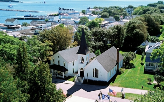
Our next destination was Mackinac (pronounced Mack-in-aw) Island, located in the eastern part of the infamous Straits of Mackinac, separating Lake Huron from Lake Michigan. Learning there are over 80 major shipwrecks reported in this four-mile-wide passage, we kept a watchful eye on the weather and paid even closer attention to our charts.
Mackinac Island draws thousands of tourists every summer to its charming, historic waterfront, beautiful beaches, and biking trails. Best of all, no cars are allowed, so you can safely enjoy a quiet walk, bike ride, or one of the many horse-drawn carriages. Go back in time to a more elegant era by visiting the Grand Hotel, which boasts the world’s longest veranda and the best (and perhaps most expensive) breakfast in Michigan. For a transient slip, you’ll need to make a reservation at the Mackinac Island State Harbor.
| | |
We had experienced only a few challenging sea conditions since leaving the inland waterways, so after listening to favorable weather reports, we departed Mackinac Island with little worry and headed for Beaver Island, 45 miles away. But even before we reached the Mackinac Bridge, the wind was blowing 20 knots from the south. When we transited the shallows of Lake Michigan’s Grays Reef, the wind was a steady 25 knots and gusting to 35, creating 8- to 10-foot head seas with big rollers abeam. We had experienced higher seas before, but never such confused ones. It felt as though we were in a huge washing machine- our entire pilothouse was deluged, even though we had slowed to 8 1⁄2 knots.
Now at our halfway point, there was no turning back, and there were no other options. Five hours later, we arrived at Beaver Island, beaten and bruised. Others who had recently arrived, with their own harrowing stories to tell, met us on the dock and we later gathered at the local Shamrock Bar to retell (and embellish) our sea stories with great fanfare.
While there is plenty of room to anchor, St. James Harbor is very exposed to the southeast. A summer ferry service brings tourists from the mainland to enjoy the hiking trails and open countryside, but if you want nightlife and fancy gift shops, Beaver Island isn’t for you.
We worked our way south to Chicago, exploring the Michigan side of the Lake, first visiting the elegant resort town of Harbor Springs in Little Traverse Bay. Tasteful shops, fine dining, fun entertainment and the Harbor Springs Municipal Marina make this an ideal stopover.
Just across the bay is the opulent Bay Harbor community with a 27-hole championship golf course, equestrian club, and modern marina. Historic and charming Petoskey is nearby with its galleries, museums, and attractive parks. But perhaps the main attraction of the area is Charlevoix, reached by entering Pine River Channel. There are a number of marinas here, but during summer months slips are at a premium. Fortunately, there is room to anchor in the sheltered harbor.
Heading south we visited Leland, known for “Fish Town,” an area of specialty shops and fish markets. As we left, we were struck by the soaring white sand dunes along the shore that reached majestic heights of over 400 feet.
The open friendliness of those we met in Frankfort, Ludington, Pentwater, and Saugatuck has endeared us to the area forever. When we asked a marina manager for directions to a local supermarket, we were handed keys to his car. When I struggled with repairs and maintenance projects, I was given a ride to a hardware or marine supply store. Michigan has the highest number of registered boaters in the nation, and it may also have the friendliest.
Our Great Lakes adventure ended in Chicago, where we enjoyed a variety of educational and cultural activities. Our newfound respect for Lake Michigan, however, was reinforced on our 75-mile crossing from Saugatuck-it was a rough one. Halfway across, the wind picked up, blowing 25 to 30 knots, and the 6- to 8-foot seas gave us another beating. We discovered that the Great Lakes are a truly magnificent cruising area, but we’ll never again expect lake waters to be as “smooth as a mirror.”
| Great Times On The Great Lakes Here are some resources for yachtsmen exploring the superb cruising grounds of America’s Great Lakes. Restaurants, Hotels, and Destinations: The Grand Hotel, located on Michigan’s Mackinac Island, opened in 1887 and has a rich history. In 1895, Mark Twain gave lectures at the Grand Hotel Casino and admission was $1. The hotel has also hosted five U.S. Presidents: Clinton, Bush, Ford, Kennedy, and Truman and, in 2006, the five-millionth guest checked in. The hotel boasts the longest front porch in the world, stretching 660 feet. 1 Grand Avenue, Mackinac Island, Michigan, (800) 334-7263; www.grandhotel.com The Shamrock Bar & Restaurant on Beaver Island is a good spot to unwind over a shoreside libation. Other things to do on Beaver Island include visiting the Whiskey Point Lighthouse and Beaver Head Lighthouse, both of which are operational (the latter is only open spring through fall). 26245 Main Street, Beaver Island, Michigan, (231) 448-2278; www.beaverislandmarina.com Bay Harbor is an upscale haven for yachtsmen cruising Lake Michigan. The community has a full-service marina (which will host the 10th Annual International Boat Show of the Antique & Classic Boat Society this September), a 27-hole Arthur Hills designed golf course, and upscale shopping and dining. Also, Bay Harbor is green friendly-over 300 Global Electric Motorized Vehicles in the community means it is the largest per capita user of G.E.M. cars in the world. 4000 Main Street, Bay Harbor, Michigan, (888) 229-4272; www.bayharbor.com The Bluebird Restaurant & Bar has been welcoming visitors since 1927, and has been in the Telgard family for three generations. Now one of Leland’s better-known watering holes and dining establishments, the Bluebird seats 180 diners, and can fit 100 patrons at the bar. 102 River Street, Leland, Michigan, (231) 256-9081; www.leelanau.com/bluebird Also: Dozier’s Waterway Guide has published their Great Lakes 2010 Waterway Guide, with over 500 pages of navigation information, including anchorage and marina listings, and expanded “Goin’ Ashore” sections, with lists of resources for yachtsmen that include restaurants, attractions, and stores for provisions and other supplies. www.waterwayguide.com |


