ytgnov18elect525.jpg
If you’ve ever passed a NOAA research vessel, you know they bristle with antennae, radomes, and scientific gear. And that’s just above the waterline: You can’t even see the sonar transducer array. But for all that information-gathering and data-processing equipment, the amount of bottom one vessel can cover-even with near-constant service-is tiny compared to the amount of water that passes beneath the fleet of yachts, sportfisherman, and cruisers on any given day.
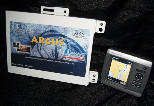
Many of those vessels have depthsounders as well as GPS-enabled chart plotters. This fact is not lost on the designers of ARGUS (Autonomous Remote Global Underwater Surveillance), a system that may change the way depth and other data is gathered and distributed.
“Look at your depthsounder as you go where you go, and ask yourself, How confident am I in that depthsounder?” says John Hersey, team lead and project manager for ARGUS, developed by SURVICE Engineering. “I think most people are pretty happy with the depthsounding they get, so just project that out-that’s the kind of confidence we can have in the collective data set.” Warning: Since ARGUS is in the planning stages and still in the hands of scientists, the discussion can get a little wonky: Don’t let terms such as “data set” scare you off.
The idea is pretty cool. Set for test release, ARGUS will be a recording and transmitting device that you install on your boat and hook up to your GPS-enabled chart plotter and depthsounder via the NMEA 0183 protocol. As you cruise, the device records your track and soundings. Then, when your boat gets within range of a WiFi hot spot, the system automatically uploads your data to the system’s network network, whisking it into that “data set.”
“It’s commonly referred to as ‘swarm technology,’ where you have a bunch of these data sources out there, just doing their thing and covering the area, and originally we had envisioned it to cover a local area as a network,” says Hersey. “But eventually these networks will start to overlap as boats from one network traverse to another.”
Keep in mind, the idea of electronic charts is based on the fact that each lat/lon coordinate has one correct depth. So the data about a depth at a certain point that you provide (including when you passed over it, which is key because the system takes tide into account) is crossreferenced with the data from the others, giving the user “statistical confidence” in the information.
The development of ARGUS began because NOAA requested proposals to show a way to track the condition of dredged shipping channels. The idea was not to replace the survey vessels, but rather to get enough information to determine where the charts most needed updating. NOAA is still reviewing the technology and has not yet made any decisions. But ARGUS may move forward on its own.
“In addition to looking for funding to establish a pilot network, we’re looking at selling a limited number of beta ARGUS units and providing free access to the data to academic, scientific, and noncommercial interests,” says Hersey. “This will allow us to step up the ongoing acquisition of depth data immediately and at minimal cost. We’re confident that the data will speak for itself, once it becomes available.” SURVICE is partnered with Marine Satellite Systems and GEOSat Solutions, which are engineering the units, and the GIS Program at Washington College’s Center for Environment and Society in Chestertown, Maryland.
The system will also provide WiFi access on board. And once the network is established, it can collect virtually any kind of data, provided the ARGUS-equipped boat carries the sensors needed. “It’s a few years down the road, but we can count fish just as easily as we measure depth,” says Hersey. “Once the network is in place you can hang anything you want off it: environmental sensors, communications, or, obviously, use it for Internet access.”
Systems may be available in the spring, and indications are that the price will be below $1,000. Stay tuned.
ARGUS Development Team, SURVICE Engineering, (410) 297-2378; **http://argus.survice.com**