When the Wind Blows
If we accept the premise that a seaworthy boat is the most important asset a mariner has, then his knowledge of weather may be the second most important.
An ability to read clouds and a basic understanding of weather signs in nature is a necessary starting point. But technology can now deliver state-of-the-art, up-to-the-minute weather data to almost any location, no matter how remote. But there’s the rub: Raw data is only useful if you know how to interpret it.
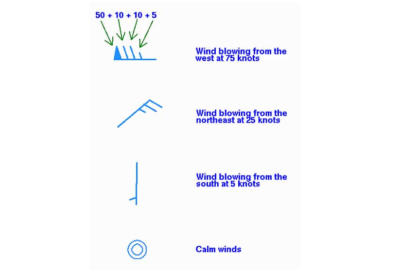
GRIB (GRIdded Binary) files are frequently used by bluewater cruisers. They contain multiple levels of weather information including data on wave height, wave period, wave direction, surface currents, water temperature, air pressure and more. The most basic and yet the most crucial information contained in GRIB files is wind direction and wind speed. Serious voyaging requires a thorough knowledge of many more components of a GRIB (because air pressure and water temperature, for example, help create larger weather patterns) but every mariner should understand the basics of reading a wind barb.
Barbs are graphic representations of observed wind direction and speed. The most important thing to remember is that the barb is a flagpole with the flags always set at the end from which the wind is blowing. A circle inside a circle represents negligible wind, a short straight flag at an angle to the main line equals 5 knots of wind and a long flag line equals 10 knots of wind. Total wind speed is calculated by adding the flags.
Most fearsome of all the flags is the pennant-shaped one that indicates winds of 50 knots an hour. If you see that one while you’re at the helm, especially if you have to add it to other flags, your options are to run for it, if you can, or heave to and pray — not necessarily in that order.