French explorer Jacques Cartier, failing in 1534 to find loose savage maidens and golden El Dorado, called Labrador “The Land of Cain.” To quote another old-timer: “God made the world in five days, made Labrador on the sixth and spent the seventh throwing stones at it.”
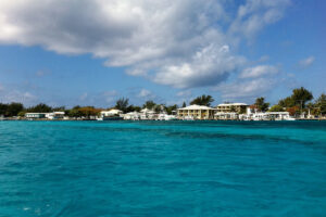
Chased by wind up the Strait of Belle Isle, which separates Newfoundland from Labrador, we swung into the Red Bay approaches at the end of July and expected to find utter desolation. Instead, the sun broke through scudding clouds, spotlighting Saddle Island’s white lighthouse. The high western shore was all green, fresh and bright against its red rock base. A white ribbon of waterfall arched down to the sea. A mosaic of small houses, a few red but most white, opened up to the northeast-the settlement itself. Two squat, tough fishing vessels lay at the wharf.
Anchoring off Saddle Island, which protects the anchorage from all ocean swells, we could not help wondering how a large wrecked ship ended up on the shoals of the inner bay. Later, we learned she had blown away from her anchorage. Perhaps the mainland did not offer much protection, after all.
However, now was mid-summer, and we were soon ashore mixing with a busload of tourists. They had crossed the Strait of Belle Isle on a ferry from St. Barbe, Newfoundland, to Blanc Sablon, in Quebec, near the Labrador border. A road along the coast from there ends in Red Bay, a major historic site in Canada.
In 1978, a horde of artifacts turned up on Saddle Island. In the seven years of work that followed, archaeologists and divers located the remains of three 16th-century ships and four boats, as well as a medieval camp, graveyard and try works, old brick ovens used to render whale oil. Research in Spain revealed that from about 1540, some 50 Basque ships made annual whaling voyages to southern Labrador. During an average season, 2,500 men produced 20,000 barrels of oil, mostly from right whales. The enterprise ended by 1600 after the majority of the Basque ships and sailors conscripted into the Spanish Armada perished during that disastrous venture against England.
Parks Canada built two pavilions to house the partial replicas of a Basque ship, a preserved open whaling chalupa craft and unearthed artifacts from the era-all superbly presented. Each building overlooks its own bay, as Red Bay has two anchorages.
The deeper and more spacious anchorage, the Basin, cuts farther into the mainland. To get there, you have to steam by Penney Island. Now a ghost of a fish processing station, the island is a monument to the mismanagement of fisheries. Codfish, according to reports from John Cabot’s expedition in 1497, were once so thick you could haul them out with a basket. The stocks persevered into the mid-20th century, until increasing numbers of vessels wiped them out. Today, it appears the cod stocks may never recover.
A boardwalk runs around Saddle Island between the sites where the Basque whalers worked and lived. It continues along the shore overlooking the Strait of Belle Isle, and gave us a clear view of a humpback whale whacking the sea into froth with its tail. Humpbacks are the most visible among the whales. In calm weather, we saw the whales floating on their sides, one 15-foot-long flipper swaying straight up in the air.
Walking out of the town eastward, we passed fenced beds of potatoes, cabbages and turnips, then came to low, rolling hills. Poking through thick layers of plants, we even found orchids with pale brown flowers. In a small indentation of the coast, we sniffed a field of sunflowers. We felt like soulless godzillas, crunching the carpet of flowers on the way back to the gravel paths into town.
In The Whaler’s, the only restaurant in Red Bay, local people assured us these plants would survive our heavy-footed abuse. As proof, they pulled out photos of Red Bay in winter: white-blanketed hills, the road resembling a tunnel between 15-foot-high banks of snow, the Harbor and the Basin flat white with ice several feet thick. In June, there were still small icebergs grounded along the shores.
These people actually liked the winter, the best time for snowmobiles. Now they were suffering from heat. James Yetman, a third generation lighthouse keeper, powered by in his skiff in a T-shirt as we stepped on deck in sweaters and parkas.
Visitors soon find out why the locals prefer winters: The summer flies come alive when the wind dies. I was photographing when small flies landed on my face and hands. I did not feel bites, but back on the boat, my face looked as if it had been dragged through barbed wire. The flies anesthetize the victim at first; the pain comes later.
And so the world looked a tad blurry through our hoods of mosquito netting when we headed up the western shore toward American Rock Man, a squarish, hospital-size boulder topping the 493-foot hill named for a World War II lookout. We trudged through tuckamore-wind-pummeled, contorted forest of conifers and evergreens, 3 feet high in the protected ravines. Up top, huge granite blocks lay scattered on a plateau covered with berries. Involved as we were in eating, only by chance did we spot a veiled white dot out in the Strait of Belle Isle-our first iceberg this trip, exciting enough for us to rush back to the boat.
At night or in fog, icebergs are a threat to navigation; in clear daylight, they rise as objects of beauty. The one off Red Bay floated serenely in the sunshine like a giant whipped egg white dessert.
Kittiwakes wheeled overhead, Common Terns fed on sprats, and a long line of jumping dolphins carried on northward. We nearly missed a whale’s head, dark in swirling waters like a rock awash. Broken-off ice chunks, smooth growlers and sharp bergy bits surrounded the area.
The ice was on the move again, a reminder that summers are short in the Strait of Belle Isle.

