Enjoying a pleasant, uneventful spring crossing of the Gulf Stream, we return to West Palm Beach after a two-week side trip to the Bahamas. Even though we’ve been in the islands only a short time, we experience a sense of culture shock as we enter Lake Worth Inlet and thread our way through a maze of personal watercraft, paddle-boarders, runabouts, center-consoles, sport-fishermen and megayachts.
To avoid physically checking in at the U.S. Citizenship and Immigration Services office, we had previously obtained a Local Boaters Option Card, so we just need to check in by telephone upon arrival. We tie up to the floating docks of Lake Park Harbor Marina, one mile north of the inlet, where we plan the final leg of our one-year, East Coast virtual cruise.
During the past 11 months, we have traveled more than 2,500 nautical miles, leaving Annapolis, Maryland, in spring 2013 to explore New England during the summer, venturing as far “Down East” as Isle au Haut, Maine. We then backtracked to the Chesapeake Bay in time for the Annapolis-area fall boat shows. Eager to stay ahead of the approaching cold temperatures, our trip down the Intracoastal Waterway to the Florida Keys was a bit hurried. Our return trip, however, will allow us time to revisit our favorite stops and discover new ones.
Mouse over the chart to see where to eat, dock, and explore in Beaufort.

From Lake Park, we slowly work our way up the Florida coast to the historic town of Brunswick, Georgia, 5 miles off the ICW at mile marker (MM) 680. It happens to be the first Friday of the month, when complementary refreshments are served in the shops and galleries, and live outdoor music adds to the festive atmosphere. We return to Isle of Hope, Georgia, (MM 590) to spend more time in Savannah, which is easily accessible by public transportation. While we usually stay clear of touristlike activities, a persuasive horse-and-buggy driver changes our mind, and we thoroughly enjoy an entertaining tour of this historic city. After Savannah we revisit Charleston, South Carolina, one of our favorite Southern towns, and then it’s on to quiet Georgetown (MM 405). The downtown is a designated National Historic District, and its beautiful antebellum homes, museums, restaurants, shops and markets are within walking distance of our marina.
The current conditions are ideal for a run up the coast on the outside, but we choose to meander up the ICW, taking in the local scenery and enjoying the many stops along the way. Myrtle Beach (MM 365), Southport, North Carolina, (MM 309) and Wrightsville Beach (MM 285) are among our favorites. More than a dozen bridges cross this stretch of the waterway, and boats with masts higher than 65 feet will have to run outside to Beaufort Inlet, North Carolina (MM 203). While the shoal areas are not quite as challenging as those farther south, they do exist and require one’s constant attention to the charts and markers to avoid a grounding.
Arriving in Beaufort, we tie up along the historic waterfront at Beaufort Docks. The marina’s floating docks, full-service amenities and convenient location to downtown make this an easy choice. Across Taylor Creek, we spot a couple of wild horses in the distance on Carrot Island. Taylor Creek is a popular anchorage for cruising boats, but the swift current and narrow channel dictate deploying a Bahamian-style, two-anchor system to minimize swinging room. Beyond Carrot Island is Shackleford Banks, an isolated barrier island where local ferries and tour boats bring tourists to see the surviving herd of wild Spanish mustangs.
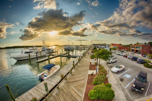
Front Street in downtown Beaufort offers cruisers walking access to great shopping and area attractions. Photo courtesy of the Zimmerman Agency.
Beaufort (pronounced BOH-fert) is much more than a quaint Southern town; it boasts a rich nautical history. Its mild climate and strategic location encourage boaters traveling south in the fall and north in the spring to stop and take advantage of the area’s top-notch boatyards and experienced workforce. Referred to as the “Gateway to the Caribbean” and just 675 miles from Bermuda, Beaufort is often a temporary home to an offshore sailing vessel or long-range trawler preparing for a serious blue-water voyage.
To learn more about Beaufort’s nautical past, we visit the North Carolina Maritime Museum on Front Street. Permanent exhibitions spotlight the local seafood industry, whaling industry and history of North Carolina’s coastal life-saving services. We especially enjoy Blackbeard’s Queen Anne’s Revenge, an exhibition of artifacts from the pirate’s flagship that went down in Beaufort Inlet in 1718. Discovered in 1996, the shipwreck provides valuable insights into the lives of 18th-century pirates.
The next day we embark on a kayak exploration of the Rachel Carson Reserve, a complex of small islands across Taylor Creek. Following the recommendations of a guide, we bring fresh water, snacks and bug spray. The boardwalk on Carrot Island takes us to an overlook of Shackleford Banks, and we are fortunate to get a glimpse of several wild mustangs. While my wife and I are not avid or knowledgeable bird-watchers, we are treated to the sight of several of the 200 species of birds that dwell in these beautiful, protected salt marshes.
Later in the week, we take advantage of the ideal weather conditions to head out of the inlet and run the 6 miles to Cape Lookout National Seashore, where we drop the hook in 6 feet of water near Day Beacon 6. Well protected from the ocean swell, we’re surrounded by beautiful white-sand beaches and crystal-clear aqua blue water. This undeveloped national park, located on a barrier island, has no paved roads, concession stands, hotels or bridges to the mainland. Its black-and-white, diamond-painted lighthouse was commissioned in 1859 and continues to light the way for offshore ships. We join a group of visiting Boy Scouts for a 15-minute park ranger presentation on the life of a light keeper, and afterward we walk for miles along the pristine, nearly deserted ocean beach. While we don’t spot any of the loggerhead sea turtles that often nest along the beaches, we notice a mysterious shadow about 20 yards offshore. It’s about 10 feet long and slowly moving parallel to the beach. Maybe it’s a dolphin or a whale? But our imaginations fill our heads with the soundtrack to Jaws.
Our virtual cruise of the East Coast is about to end, and in less than two weeks we’ll be home in Annapolis adjusting to life on the hard. As we make our last few stops, Oriental, New Bern, Coinjock and Norfolk, Virginia, we already begin to plan our next cruise. Hopefully, you’ve enjoyed following us up and down the coast as we’ve shared our adventures and discoveries with you. More important, we hope our 12-part series has inspired you to start making plans for your own extended cruise of the East Coast. Do it all at once or do it in smaller segments. But above all, just do it
On Our Way Home

Morehead City, NC 34° 43′ 40″ N 76° 44′ 48″ W
Before heading north on the ICW, we stop at Beaufort’s sister city, Morehead City, less than five miles to the west. We get a slip at Morehead Gulf Docks located across from Sugar Loaf Island and within walking distance to restaurants and shops. Like Beaufort, Morehead City is a popular stopover for captains traveling up and down the coast who want to bypass the offshore waters of Cape Hatteras. Repair and maintenance services of all types are available. Based on the number of commercial and charter fishing boats we see, this is a center for sportfishing activity with a number of major tournaments being held here. We’re nearly overwhelmed by the number of restaurants near our marina, but we settle on the Rudy Duck Tavern and have a great dinner. The next morning we enjoy browsing in the many antique shops nearby before picking up some boat supplies at Ace Marine & Rigging.

**Bellhaven, NC 35° 32′ 35″ N 76° 37′ 24″ W **
About 70-miles north of Morehead City, we stop for the night at Bellhaven (MM136) and tie up along the bulkhead at Bellhaven Waterway Marina. Most boats here are in transit, as this sleepy little town is strategically located between the Pamlico and Alligator Rivers. A walk through town reveals several empty storefronts with “For Rent” or “For Sale” signs, and a couple of shops that appear to be in business are closed for the day. Hurricane Irene hit this town hard in 2011, and it’s been struggling to survive. But we wind up having dinner at the Fish Hooks Café and are pleasantly surprised by its good food and reasonable prices. Some of the historic homes of the 1800s and early 1900s have been lovingly restored, and there are new developments underway along the waterfront. Transient slips here are limited, so it’s a good idea to call ahead before stopping.
**Coinjock, NC 36° 20′ 35″ N 75° 57′ 09″ **
After crossing Albemarle Sound, which can kick up a nasty chop, we need to decide on whether to proceed north via the Dismal Swamp or the Virginia Cut. Since we chose the Dismal Swamp on our way south earlier in our one-year cruise, we head up the North River to Coinjock (MM50), which will eventually lead us to the Virginia Cut. Coinjock is a popular stopover for boaters traveling the ICW, as it is provides comfortable resting places at two marinas with long face docks along the narrow, protected North Carolina Cut. Since we’re heading north, we tie up to the 1200-foot bulkhead at Coinjock Marina (on the east side of the channel) where we also fill up our fuel tanks. Their dockside restaurant is famous for its 32-oz. prime rib, but we control ourselves and settle for a more healthy stuffed flounder dinner. There’s not much to see or do here, so we simply enjoy a relaxing evening onboard thinking about what it’s going to be like returning home after being away for a year.

Great Bridge, VA 36° 42′ 50″ N 76° 14′ 20″ W
At MM 12, we arrive at the Great Bridge Bascule Bridge, which opens on the hour and is synchronized with the operation of the Great Bridge Lock at MM11.3. There is only a 2-foot difference in the water level, so the entire operation of locking through takes about a half hour. Because there is no commercial traffic traveling with us, we are able to tie up to the south side, which has a good fendering system. We now have a short run up the south branch of the Elizabeth River to reach Portsmouth. It’s important to note the weekday rush hour closures of the Dominion Boulevard Bridge at MM8.8. Fortunately, we have reached it at noon in time for its on-the-hour opening. We once again tie up at the Tidewater Yacht Marina in Portsmouth. The next day we begin our one-week trip up the Chesapeake Bay, returning to our home in Annapolis, exactly one year from when we left.