Panama5insidelarge.jpg
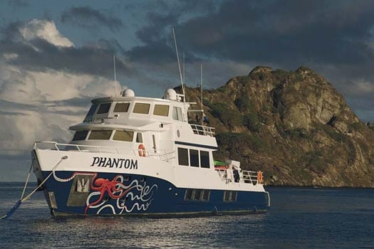
When professional treasure hunter Rob McClung asked if our boat Phantom could be the mothership on a weeklong expedition to the wreck of the Spanish Galleon San José, he didn’t have to ask us twice. We dropped everything, hoisted anchor, and got underway for Panama.
Our first experience with treasure hunting came shortly after my son, Matthias, 14, and I arrived in Florida. Docked in Ft. Pierce, we were invited aboard by our dock neighbors, the crew of the New World Legacy, to hunt for the treasure of the 1715 Plate Fleet in Sebastian. The trip was a success-a beautiful gold bar embossed with King Philip’s official stamp was recovered-and Matthias and I were hooked. Over the following year, Phantom continued her journey south, roughly following the trail of Spanish treasure to Cuba, the Cayman Islands, Jamaica, Colombia, Honduras, and finally down to Panama.
Now better known for its canal and fishing, Panama was once an important port-of-call for Spanish fleets loaded with riches from the New World. Pirates like Henry Morgan ventured into Panama’s waters to plunder Spanish fortunes while its many treacherous reefs, shoals, and underwater pinnacles helped send countless treasureladen galleons to the bottom of the sea.
The search for San José has been a long-time project for Rob and his Panamanian businesss partner Saki Lymberopulus of Blue Seas Exploration. (In the U.S., Rob has an alliance with Joseph Fuller of Oceanic Expeditions.) They have accumulated exhaustive research on the San José and acquired the permits necessary to search and survey the wreck site where the galleon first hit a reef, about 80 miles off the coast of Panama, near the Perlas Islands. In fact, Rob had discovered the wreck site of the galleon San José in 2002, but hadn’t been able to get back since. His permit would allow Rob to keep 50 percent of any treasure he found. Artifacts would be split, with the government taking 35 percent of the haul. Anything pre-Columbian was to be turned over to the Panamanian authorities.
When San José hit the reef on June 17, 1631, she was sailing with three other galleons and one smaller vessel of the South Seas Armada, all loaded with Peruvian treasures and all in deplorable states. Twenty years old, San José was the oldest vessel in the fleet, so when she violently struck bottom near Punta Garachine, she didn’t stand a chance. The keel ripped out on the reef, spilling ballast and silver from her belly like a busted piggy bank. No one knows exactly how much treasure she had aboard because the silver master of the San José took that secret to a watery grave. And even though the Spanish crown conducted salvage operations, researchers in the archives of Seville have surmised that unknown fortunes were lost. It’s believed that thousands of priceless silver and gold artifacts were never recovered.
In the weeks before our own salvage operation began, a team of divers was assembled, provisions were bought, and plans were excitedly discussed. Dick and Tisha Peery and their son, Jesse, who had worked with Rob on other wrecks, agreed to finance this expedition. They would also provide hands-on assistance for Clay Jorgensen, owner of Panama Divers, who was in charge of diving operations on the site. When our departure date finally arrived, an avalanche of line, scooters, underwater metal detectors, and assorted dive equipment was loaded onto Phantom (see “Charter Your Own High Seas Adventure,” page 60).
We approached the beautiful Perlas Islands in the early evening, when there was still enough light left to get some work started and it was decided that a launch should go ahead and make a quick preliminary dive of the San José site before it got too dark. One thing that was immediately apparent was that we’d be dealing with a monster current. Even with divers providing underwater assistance, it took three tries to hook the anchor to the bottom.
Once secured, Rob and his team went into the water with long bundles of ropes to set grid lines along the wreck site at intervals marking north, south, east, and west. By the time the divers exited the water an hour later, they were so fatigued they could barely clamber aboard the launch.
The next day, Matthias and I got to dive with the rest of the team, taking video and still pictures to document their work. Based on the last day’s experience, we brought along an extra launch as a safety boat to catch divers swept away by the current.
As I watched everyone go into the water, it was hard not to feel intimidated. Struggling against the powerful surface current, the divers had to haul with all their might to make any headway. Once a diver made it to the anchor line, it was still a battle to get down to the bottom since the line strained and slackened with the force of the current.
As Matthias went into the water, I watched helplessly from the surface while he twisted around the anchor line like a spinning lure,struggling to get both the video camera and himself safely down to the bottom. Then it was my turn.
Gritting my teeth and grasping onto a surface line, I jumped into the water. As soon as I was in, the current ripped me back like a rag doll. “Oh my God,” I thought as I gasped for air. “How is anyone supposed to do this?” But I forged ahead like the other divers, slowly, painfully hauling myself, hand-over-hand on the surface line to the bow of the boat, which was by now producing a sizable wake.
That wasn’t the end of the battle, however. Going down the anchor line was another challenge. As I struggled to move toward the bottom, the anchor line was continuously yanked up and down. I made slow progress, inch by inch, and when I looked down at my gauge I realized I’d used up almost half of my air supply just getting down to the site.
At the bottom, a problem with visibility-or rather the lack thereof-quickly became apparent. Though it was possible to take photos in the murk, it was extremely difficult to keep track of other people. If you got more than ten feet away from your dive buddy, it was impossible to see him or her. The only thing that prevented me from being completely disoriented were the grid lines.
Meanwhile, I was documenting the divers’ surveying work. In less than two hours of total dive time, they had strung out a large, well organized grid system over the wreck site. I couldn’t help but admire their dedication to the hunt.
After three dives the team was tired, but not discouraged. Although no artifacts had been found, they had mounted an impressive effort in mapping out the site, and were ready to piece together clues from history.
We were not alone on this hunt, however. Sometimes, as the team discussed the day’s adventures between dives, large sharks were seen cruising along the surface. On one occasion, while Clay and Rob were laying out grid lines, a shark at least twelve feet long was seen swimming nearby. When it came to the spot above Clay, it dove right into the center of his bubbles. A momentary silence was held as everyone on the surface silently paid their last respects to the master diver. But despite our fears, Clay surfaced-he hadn’t even seen the shark!
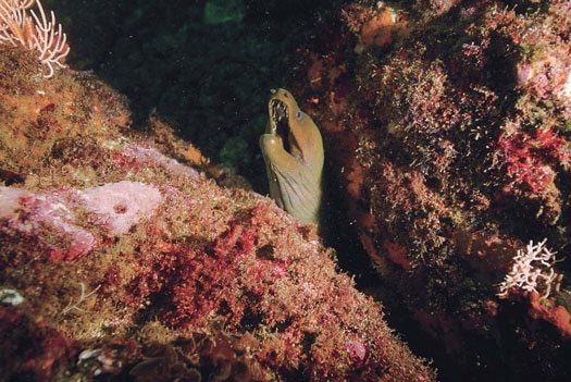
A very real threat came not from sharks but from the moray eels and stonefish that lurked in the rocks, sometimes appearing to be convenient handholds in the murky water. In order to prevent being bitten accidentally by one of these creatures, we all wore thick gloves.
| | |
A few dives later, waiting on the boat to help divers back on board, I was surprised to notice Rob surfacing after less than 20 minutes underwater. The team’s painstaking organizational work had paid off.
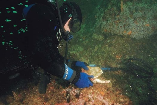
“I’ve found pottery!” he yelled. Everyone on the surface piled onto the safety boat to see the colorful shards of an amphora, a vessel used to hold foodstuffs. Exhilarated by his discovery, Rob went back down to the site, and spent the rest of the dive marking more and more shards but leaving everything where he found it.
Each piece of pottery was methodically situated near the grid lines to map the spread of the San José’s doomed cargo. Rob excitedly explained to me that the amphorae were evidence that we had relocated the site, where six years earlier, he had brought up more than 200 silver coins, a silver bar, three bronze cannonballs, pottery, and majolica. As the hunt slowly progressed, we began finding ballast stones mixed in with the broken pottery-a definite sign that we were closing in on San José’s lost cargo of priceless silver. We were once again at the beginning of the treasure trail.
| | |
It was frustrating to have to leave at the end of the week, knowing how close we were to the silver, but we’d planned for a week and we were out of time. We were also physically exhausted. The team felt good about the groundwork we’d laid, though. We had managed to find and map out a great portion of the treasure trail to San José. A few weeks off would let us replenish the exploration coffers and get some rest before the next attempt.
We’ll be following the treasure trail of the San José again soon, and my hunch is that this time we’ll hit the motherlode.