“Yacht with the green hull, yacht with the green hull, this is the Mexican Navy on channel 16,” said a Spanish-speaking voice on the VHF.
Damn! The gray 100-foot patrol boat changed course and headed right for us. After 2,800 miles of unimpeded progress from Florida, I feared that men with guns were finally about to board the 37-foot trawler yacht I was delivering to Ensenada.
“Mexican Navy, Mexican Navy, this is the yacht with the green hull. Ho’Okele. We’re an Estados Unidos yacht en route to Ensenada. Our last port was Barillas in Jiquilisco Bay in El Salvador.” The patrol boat was a now a half-mile away.
“U.S.A. yacht. What is your name?”
“Ho’Okele”. A difficult word, I admitted in Spanish. “Ho’Okele.”
“What is your port of origin?”
“Florida. Florida, Estados Unidos.”
“Bien, U.S.A. yacht. There is a storm now. Not here, but up ahead. Forty-five-knot winds and 10-foot seas. You ought to be very careful.”
“Is this storm of the Tehuantepec type?” I asked. That’s where we were, in the Gulf of Tehuantepec. Tehuantepec is to storms what Hollywood is to movies.
“Yes. Yes,” he said, and proceeded to read the day’s marine forecast in halting English.
“I understand that during a Tehuantepec storm it is less dangerous near the beach.”
“Yes. Stay near the beach, a half-mile or less.”
“Thank you for your help, Mexican Navy.”
“We will be here if you need us, captain. Adios.” The Navy resumed its patrol, and Ho’Okele headed toward the beach. I felt touched by the Mexican Navy’s concern.
Some cruisers might tell you that Tehuantepec storms are difficult, even impossible to anticipate. Not true. They also might tell you that navigating through them can be nearly impossible. Also not true. With the proper electronics and some local knowledge, anticipating and making your way through these storms can be done safely.
The U.S. Navy’s weather prediction center, known as FNMOC, clearly predicted that a gale would be brewing in the Gulf of Tehuantepec days before the event. It was plain to see in the wave height and direction section of FNMOC’s Web site, which I had consulted before leaving Barillas.
Tehuantepec storms originate in the Gulf of Mexico and occur when a high-pressure system follows a low across Texas and into the Caribbean. This high brings north winds, and these funnel through a break in the mountains that run down Mexico like the plates of a stegosaurus. That wind accelerates, then roars out the other side with gale force, creating square 10-foot seas 200 miles into the Pacific.
Papagallos are the Tehuantepec’s less vigorous Costa Rican cousins. A week earlier, we had weathered a Papagallo storm, with its washing machine seas, so I decided we would just bull through the Gulf of Tehuantepec. In January, which sees Tehuantepec storms an average of 19 out of 31 days, a boat could put down roots waiting for a weather window.
Twenty-four hours-that’s all my crew Chef Charles and I would have to endure. Our attitude was: Get it over with.
We had left Marina Barillas in El Salvador two days before on a 475-mile run to a little resort town in Mexico’s Oaxaca region called Santa Cruz. Our conversation with the Mexican Navy occurred about 8:30 a.m. on Jan. 3. By 2 p.m., with our destination still 30 hours away, Ho’Okele was in the thick of it.
Winds were averaging about 35 knots, but as predicted, seas were only 1 to 2 feet a half-mile off the beach. That didn’t stop the wind from clawing at these waves and hurling bits of them through the air; being inside the deckhouse was like driving through a carwash.
The four remaining hours of daylight gave me the chance to work out a system for keeping a consistent half-mile offshore once the sun went down. It would have been great if the shore ran true because the autopilot was unaffected by the force of the winds, but the shoreline ran from southeast to northwest, becoming incrementally westerly as we got into the gulf.
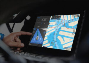
Obviously, the radar was a terrific tool for maintaining our interval, so I would get the boat on course by using the radar, then put a cursor waypoint on the plotter so the autopilot would have something to steer to. Then it would be just a matter of monitoring our progress and adjusting our course with new cursor waypoints as the shore curved.
All this sounds pretty straightforward, and in daylight, it was. Night would be different. There was no moon, nothing to see but brine and blackness. We might as well have been in a submarine. So, besides keeping a foot on the beach, Ho’Okele’s radar would be our only way to avoid collision with other stray vessels or big debris-a process of regularly varying range and gain.
The one problem that surfaced with our Tehuantepec video game was the electronic chart. It was wrong. While we were motoring a half-mile out, the chart showed Ho’Okele plowing sand a half-mile inland. “Fine”, I thought, “as long as the error is consistent”, but that was tired thinking. Because we were incrementally changing course, the error could not stay constant relative to the boat’s heading.
It was a lapse that almost bit us on the butt, and I think it happened around midnight.
I was looking down into the chart plotter and saw a number changing-7, 6, 5, 4, 3. Whoa! That’s the depth sounder readout! I took control of the boat and turned us 90 degrees to port to head offshore. The depth rose almost immediately to 5 feet but took what seemed like forever to get back above 10.
We had almost run into a sand berm alongside the mouth of a big lagoon. The chart showed this obstacle more than a mile ahead, but of course, the chart was wrong. I knew that, but I’d only been taking it into consideration for keeping an interval from the beach, not avoiding stuff ahead of me.
We went out about a mile to skirt the sandbars and found ourselves bouncing in square 4- to 5-foot seas, which utterly discombobulated the autopilot, so I hand steered until we were back on our half-mile interval. I let Chef Charles play the video game for a couple hours while I took a nap.
At 4 a.m. I took over again, wearing a sweatshirt against the cold. By the radar, I thought, we were skirting the shore a little too closely, but I had a heck of a time getting it to the correct interval and steering by waypoint at the same time. After a two-hour nap, I was out of practice.
Later, as we skirted the petroleum port of Salinas Cruz at the head of the gulf, our course changed to follow the coast, which brought us stern-to the wind. Ho’Okele adopted an easy motion. With a comfortable platform and great view of the Sierra Madre mountain range to starboard, it was a good time to reflect.
I didn’t regret having wrestled a Tehuantepec, if only because it gave me something to write about. But I must admit: I would not have wanted to do it in my own boat, a 41-foot sailboat. Even with its enclosed cockpit, the passage would have been very wet and noisy with the wind whistling through the rig and the halyards slapping. I couldn’t think of a better boat for the T-pec two-step than a motor vessel with a form-stable hull. Though a round-keel trawler with fin stabilizers and fairly shallow draft would also have done just fine.