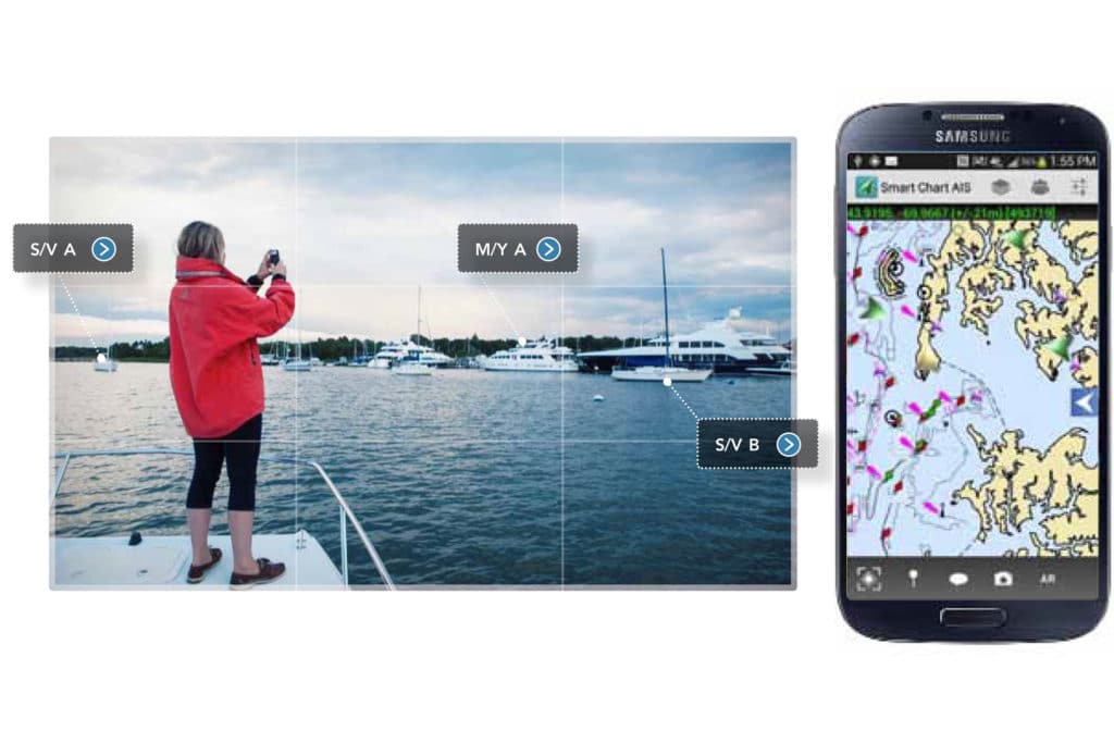
Smart Chart AIS
Boating on Puget Sound’s heavy-traffic waters has made me seriously appreciate the Automatic Identification System (AIS). Unlike radar, which suffers from attenuation issues when operating in heavy precipitation, and which can’t peer around landmasses, AIS provides an accurate view of other AIS-equipped vessels that are operating within VHF range. It also offers a means of direct communication, provided that both parties have preprogrammed their unique identification numbers. The only significant drawback, however, is that AIS requires onboard power and specialized equipment — prerequisites that exclude most small-boat traffic.
Now there’s an app for that. “Our concept was that, if you have a boat, you have a smartphone,” said Chuck Benton, owner and chief technical officer of Technology Systems Inc. (TSI). Benton’s company created Smart Chart AIS, an app that displays nearby AIS targets while sharing your vessel’s position information with other Smart Chart AIS users (among other features). He personally owns several small boats but only one smartphone, which made him realize that smartphones/tablets — not specialized equipment — offered a solution. The phones and tablets are ubiquitous, they’re registered to an individual, and they allow for direct person-to-person communications.
After securing about $750,000 in research funds from the Department of Homeland Security, his company went to work developing the app. And this is just one example illustrating the emergence of “AIS Class E” technology, which is Benton’s unofficial term for something that could improve everyone’s on-the-water safety.
Smartphones and cellular-enabled tablets come with a built-in feature called “location services,” which gives apps access to your device’s GPS information. When activated, the Smart Chart AIS app reports this location information via cellular at device-determined intervals (e.g., a brand-new smartphone with a strong GPS might transmit once per second, while an older device with a weaker GPS might transmit only once every 30 seconds) through a local Internet access point to a cloud-based AIS Class E server. Here, it’s compiled along with other users’ Class E information. Each active Smart Chart AIS app polls the server for information about other Class E targets within its area of interest, which is pushed out — again via cellular — every five seconds. TSI has also incorporated a gateway that includes nationwide AIS data (Class A and Class B information that’s obtained from aishub.net) in these updates, as well as weather information from Nexrad radars. This information is received by each user’s device and layered onto free, NOAA-supplied charts.
Benton specified that, unlike AIS Class A or Class B, AIS Class E is limited by cellular coverage and is not intended for navigational purposes, but, he said, “We believe that there will be cellular service when a boater is [negotiating] heavily trafficked areas.”
While it’s helpful to create a network where one kayaker can see another kayaker, the big-picture objective is to allow yachts and ships to see these small craft (and vice versa). Getting Class E targets onto the helms and bridges of nearby yachts and ships, however, isn’t an integrated process. Currently, the easiest method, said Benton, is for yachts and commercial traffic to carry a smart device on helms/bridges that’s running Smart Chart AIS, allowing the crew to monitor small-vessel traffic, but this could change in time.
“Our [traditional AIS] equipment could be updated, via software, to show this information,” explained Jeff Robbins, co-founder and CEO of Vesper Marine, the Auckland, New Zealand-based AIS experts. While Robbins is interested in this new technology, he was careful to differentiate between actual AIS information and Smart Chart AIS data, which he described as a blend of location services and marine traffic information. “People need to understand the limitations,” added Robbins.
Unlike AIS Class A and B, which use a unique Maritime Mobile Service Identity (MMSI), AIS Class E devices use a dual “user” and “vessel” identification scheme and aren’t necessarily associated with a unique MMSI (but they can be). Because of this, said Benton, instead of trying to integrate Class E information onto a dedicated AIS display, a far simpler path for seeing Class A, B and E data on the same screen (aside from your smartphone/tablet) is via a third-party multifunction display that’s connected to an AIS receiver and a Wi-Fi router. Smart Chart AIS could share information with the display over wireless, avoiding the technical complication of slotting Class E updates around the Class A and Class B transmission schedules. Also, since Smart Chart AIS transmits fresh data every five seconds, sharing Class E target information via Wi-Fi could potentially deliver greater accuracy than on Class B, and possibly some Class A, targets.
It’s important to understand the limitations of an app-based solution such as Smart Chart AIS, especially in emergency situations. According to Jorge Arroyo, a civilian engineer at the U.S. Coast Guard who has been instrumental in writing AIS regulations, all Coast Guard rescue operations use nationwide AIS data, not third-party app-based information. This means that Class E data first needs to be recognized and incorporated into official AIS transmissions before it could help with search-and-rescue operations.
Still, some software solutions have been developed to increase user safety. For example, Smart Chart AIS took the wise step of creating its own Class E icons, which are slightly larger than Class A or Class B targets, providing instant differentiation between a supertanker and a considerably smaller sport-fisherman. Moreover, Smart Chart AIS uses a color-coded system to reflect the accuracy/quality of a target’s position information. For example, said Benton, a green-color target is one that the app deems to be spot-on accurate, whereas a yellow target should be considered suspect and a red one is downright sketchy. Also, Benton said he hopes to add an SOS function that, when tapped, could trigger an alert that would be immediately pushed to all nearby Smart Chart AIS users.
Currently, the biggest hurdle that AIS Class E faces is some boaters’ reluctance to register their software and share their location information, for fear of Department of Homeland Security overreach. “There’s always a part of society that says, ‘The DHS wants to track me? No way!’ irrespective of how much it might actually help them,” explained Benton, who notes that the program is completely voluntary. “There are good people in the government who want to enhance on-the-water safety while also helping the [Coast Guard] and the border-security guys to do their jobs.” Also, added Benton, Smart Chart AIS could potentially lead to smoother international border crossings and possibly even reduce the risks of a routine Coast Guard stop, if people are willing to share their tracks.
Smart Chart AIS is the reference implementation for this new technology, so these users are (currently) the only people enjoying AIS Class E information. Smart Chart AIS passed its beta testing last summer and is now free for Android and iOS platforms, although Benton eventually envisions monetizing the app. Moving forward, Benton would like to see this technology become an international standard, and he plans to create application programmer interfaces that will allow other developers to use AIS Class E information to supplement their own electronic chart systems software.
For now, however, a helm-mounted tablet that’s running Technology Systems’ Smart Chart AIS app provides another electronic safety layer for anyone negotiating waters that are popular with small-boat users, and a smartphone that’s running the app is free insurance when taking out the tender for the day.