I obtained my last Loran A fix at 2355, 31 December 1980.
Until that moment, my Konel DL-155 D-X Loran A was among the most sophisticated electronics aboard Bonne ‘Etiole, my Irwin 46 ketch. The unit had a small, green phosphor CRT screen and was festooned with 15 control knobs—12 of which had to be adjusted to determine a single line of position. The process involved me looking for a single “blip or, as it was occasionally called, a “blade of grass, that was motionless against a screen of hundreds of rapidly moving blips. Then I had to fiddle with the knobs to center and magnify the signal, and adjust the controls to superimpose two images. After accomplishing this, I had to record the positions of the three station control knobs, along with the five numbers that appeared in the “delay windows. That gave me a single line of position I could locate only on a properly annotated chart. Since the line of position usually did not coincide with one of the plotted lines, I had to use the Loran Linear Interpolator printed on the chart’s margin. Repeating this process once or twice helped me obtain the additional lines of position needed to define a fix, or in the case of a fast-moving boat or aircraft, a moving fix.
Ah, the simplicity of the modern GPS.
The progress we have witnessed in marine electronics in the past 30 years borders on the astonishing. In 1973, a well-equipped yacht boasted an electronics suite made up of VHF and AM/SSB HF radio transceivers, analog radar, autopilot, Loran A navigator, loud hailer and depth sounder or fishfinder. Although the purpose of each device remains the same today, modern helms differ dramatically. Increased processing power has led to better software. Cost has decreased, as has the size of each piece of equipment. All the while, our capabilities have increased-and promise to do so again, perhaps eclipsing our current technology in the next 10 years.
While it’s always a good idea to look forward, every conscientious navigator occasionally looks aft to evaluate his vessel’s track across the sea.
And so we glance over our shoulder to see how far marine electronics have progressed during the past 30 years.
THE RUBBER HOOD
Three decades ago, VHF radios were typically large and could operate only on a limited number of channels. My Konel Gemini VHF radio, at a price of about $500, boasted just 12 channels, plus one weather channel. Any skipper who wanted to add channels to some of the early radios had to insert additional frequency control crystals-an operation that often required cutting wires on a diode matrix circuit board. A two-channel handheld VHF radio sold for $300 and resembled a military walkie-talkie in shape and size. SSB radio usually provided just one or two frequencies in each operating band.
HF radios had to be installed by an FCC-licensed technician. From sublime to ridiculous: In 1973, we could buy depth sounder kits from Heathkit and assemble the units ourselves.
Radar was common 30 years ago, but the rapidly fading glowing green trace on the CRT screen was best viewed using a light-excluding rubber hood. After some use in a hot climate, this “tool provided an unforgettable olfactory experience. A truly portable radar, the Whistler, sold for $445. Skippers held it out and listened for a tone in their headphones to announce a target acquisition.
Fishfinders inscribed black blurs, marks and lines on a moving paper chart, with occasional puffs of smoke.
Depth sounders whirled neon lights on circular cards, flashing dimly at each emitted and received ping signal.
Electronic means for position fixing included the radio direction finder, a device rarely capable of providing a line of bearing accurate to better than about plus-or-minus 5 degrees. Some vessels boasted Transit satellite receivers, which yielded a line of position if you waited a few hours for the satellite to pass within view. Loran A receivers were reasonably common, but their use, as described above, required an abundance of skill and patience.
SIX-HOUR ACQUISITION
While Loran was developed in the United States in the early 1940s, it was not until the late 1970s and early ’80s that the full-capability Loran C gained popularity and brought about a major change in navigation practice.
Before that day arrived, my SRD Loran C, encased in its cast aluminum vault-like enclosure, was a proud addition to my boat’s nav station. It could define a number of lines of position automatically. While an improvement compared with technology of the past, my unit could not compute latitude or longitude. I had to use a chart overprinted with Loran C data.
More capable microprocessors meant the TD-only Loran C would be superseded by full-capability units that could automatically compute geographic position, course over ground and speed over ground-and store defined positions using a new definition, the waypoint. Navigators could see a display of cross track error when navigating to a waypoint, and the data could be sent to an autopilot.
This was heady stuff, until the military made GPS satellites available in the late ’80s. The first GPS with which I had experience was made by Magnavox, sold for about $10,000 and was the size of two shoeboxes. The day we installed it on a friend’s 88-foot ketch, we had to wait almost six hours for the first satellite to pass overhead, bringing it to life.
THE 4-BIT PROCESSOR
The development of GPS units is an excellent example of Moore’s Law: The number of transistors in a microprocessor doubles every 18 months, while the cost is reduced by half. Intel’s first widely used microprocessor, the 4-bit word 4004, contained 2,300 transistors. By comparison, the latest Intel microprocessor contains 5.5 million transistors and processes 64-bit words 5,000 times as fast.
Progress in position determination has been applied in concert with the amazing development in stored program computers to produce today’s integrated chart navigators.
And keep this in mind the next time your system acts up: The capability of the navigation suites on many of today’s recreational boats far exceeds what was available on the largest military vessels only five years ago.
NIXIE NUMERALS
Display technology, meanwhile, progressed from early digital readouts that included hard-to-see Nixie tube numerals to the first equally hard-to-see LED arrays. Next came monochrome LCDs, which had little liking for weather. They slowed or ceased to work when too cold, and they went black when too hot.
The growing use of laptop computers did a great deal to drive the development of reasonably viewable display screens, built in part with backlighting and transflective technology (“Sharp Turns, April 2002). Still, even today, many displays are sorely lacking in all-too-common extreme temperatures and bright sunlight.
A prototype OLED screen, now in research laboratories, is expected to make our LCDs obsolete in a few years, though history has proved that when it comes to displays, nothing is ever quite good enough.
REAL-TIME FUTURE
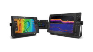
In the meantime, what we see on our screens is being driven by ever more powerful and less costly microprocessors (and associated digital memory). Today’s radar images are digitized, colorized, processed and combined with navigation data to provide a real-world, real-time and even predictive image of the surrounding area. Fishfinders display water temperature, vessel position, course, speed and drift information. They can almost tell the user what type of fish is swimming beneath the hull.
Today’s VHF and HF/SSB radios provide access to every authorized channel, and allow voice and digital communication-including e-mail. Licensed technician installation is rarely required. Handheld radios are available in every form and frequency band. Satellite communication equipment includes handheld phones usable on any ocean. It also includes fixed systems that use gyro-stabilized antennas to provide high-speed Internet access, as well as voice and other digital communication, plus television in many areas.
Autopilots are ever more capable. The increasing use of gyro-stabilized heading sensors coupled to software-managed control algorithms ensures a vessel will remain on course, even during difficult sea conditions. These same superior heading sensors also contribute to navigation safety through the radar’s automatic plotting aid function (“Free Your Mind, March).
Some recent products, including satellite-linked downloads of weather information, are supplementing equipment such as weatherfax, while virtually real-time access to National Weather Service radar and other meteorological information is becoming available through services initially offered to aviation. Skippers can now watch, in real time, as a thunderstorm rips across their local bay.
Sure beats hunting for a blade of grass in a sea of blips.