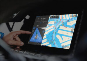
The new Furuno FR-2105-B series is a professional-level black box radar, a system whose display is independent of all signal processing and control elements. Almost any super-fine-pitch computer monitor can be installed close to your bridge deck windows to function as your radar screen, putting the monitor in the line of sight. Such positioning wouldn’t work with a conventional radar because you couldn’t reach any on-screen controls. What’s more, the FR-2105-B’s control module has single-use knobs and buttons that control its most frequently used functions. After you get used to their location, you’ll be able to use them by feel alone.
This device provides nearly every function available in radar aboard the largest commercial vessels. A look through the 120-page operator’s manual explains how the FR-2105-B has X and S band transmitters with pulse power ratings of 12 to 50 kW and antennas suitable for maximum ranges to 96 nautical miles, minimum to 1/8 nm. Standard target tracking and monitoring features include an electronic plotting aid and calculation of CPA (closest point of approach) and TCPA (time to CPA). Optional modules add an automatic radar plotting aid and a video plotter. The unit’s signal processing circuitry can even be configured for optimum detection of sea birds at ranges between 6 and 16 nautical miles. Where you find a flock of sea birds, you often find fish.
The black box is 17 7/10 inches by 16 1/2 inches by 21 inches. The control module is 20 inches by 6 inches by 2 1/5 inches, and it has function keys and a multipurpose keypad in addition to the single-purpose controls, for less frequently used functions. Any monitor measuring 15 inches to 28 inches (CRT or flat-screen LCD) can be used exclusively for radar information display, or can accommodate additional data sources.
Our test unit was aboard the 107-foot CBI Navi motoryacht Final Furlong, with the monitor serving both the radar and the Laser Plot chart system. The installation, specified by Capt. Henry Saludes and designed by Ron Muller of Electronics Unlimited of Ft. Lauderdale, illustrates the radar’s ergonomic value. The control module may be placed anywhere convenient to the helmsman, or, if a radar console is used, the control module can be placed adjacent to the display screen.
The ability to differentiate between targets closely spaced in azimuth depends on the horizontal beam width of the antenna, which is a function of the antenna’s length. The X-band antennas available for this radar range in length from 4 feet (beam width 1.8 degrees) to 10.7 feet (beam width 0.75 degrees). All antennas have an identical 20 degrees of vertical beam width. Standard rotation speed is 24 rpm; 42 rpm is available on the 12 and 25 kW units. Pulse length and receiver tuning are automatic, but you may manually control them.
You also may control the brilliance of fixed range rings, electronic bearing and range rings, the cursor, operator-defined marks, target trails and heading lines. The radar provides 10 picture modes, each optimized for a different operating environment: buoy, ship, short, long, cruising, harbor, coast, sea, rough sea and river. Each option incorporates a combination of control settings (IR, echo stretch, echo average, automatic anti-clutter, pulse length and noise rejection), and you may select display colors to match visual conditions. Background color choices are black (with green or red chart information), blue and bright blue. The color and brilliance of the echoes can be selected from the keypad.
To function properly in all primary modes, the radar must be integrated with the vessel’s speed log and gyrocompass, or other source of stable, accurate heading information. Additional input may come from the GPS position, wind velocity and sonar. With the video plotter option installed, the FR-2105-B accepts chart data input from Electronic Reference Charts, which are digital charts published by the Japanese Hydrographic Bureau.
There are five data presentation choices. Head-up, the most familiar, presents target bearings relative to the vessel’s heading. Head-up true bearing shows target bearings relative to the ship’s gyrocompass. Course-up provides an azimuth-stabilized display in which a line connecting the center of the screen with the top of the display indicates intended course. North-up depicts your heading relative to gyrocompass north and is useful when you compare the screen image with a chart. True-motion shows fixed targets as stationary echoes. Your boat and all other mobile objects move in accordance with their true courses and speed. Your position may be off-center a distance up to 75 percent of the range in use, except on the longest range scale or when operating in the true-motion mode.
Regardless of the type of data display, 70 percent of the screen is always devoted to the radar’s plan position indicator information. A column on the right shows ship’s data, data for two or three targets or data for two targets plus a graphic display of wind and depth information. Lower on the column are depth, current, wind, bearing and range to waypoint, ship’s position, cursor position, date and time. Warning messages appear at the bottom of the information area as needed.
Sea clutter (STC), rain or precipitation clutter (FTC) can operate automatically or with manual adjustment. Three levels of interference rejection are available via an on-screen menu. Two variable range markers and two electronic bearing lines are managed with easy-to-use rate-adaptive knobs. A track ball, great in rough seas, controls the cursor. You can place an EBL’s origin anywhere on the screen, enabling the radar to measure the range and bearing between any two targets. This simplifies your assessment of collision risk. Each of the two target alarm zones may describe a sector or a full circle around the ship’s position, and each can be set to alert you when a target enters or leaves a zone from any direction. The ARPA option lets you set a maximum of four alarm zones.
Two data processing modes, echo-stretch and echo-averaging, enhance target visibility. Three echo-stretch levels can improve the target’s image in the bearing direction, range direction or both. Three echo-averaging levels are available when the gyrocompass furnishes heading information to the radar. An echo-averaging mode helps suppress sea clutter by storing and comparing echo signals over successive picture frames. Reflections from waves vary from frame to frame and can be discarded, making it practical to display only repetitive return signals from hard targets. Used in addition to the conventional STC function, echo-averaging can materially improve the visibility of small stationary targets, such as navigation buoys. As with all target-enhancement techniques, however, echo-averaging must be used with care. It can reduce the chance of seeing real targets that return marginal amounts of energy to the antenna.
The standard electronic plotting aid allows plotting of as many as 10 targets, with as many as five past positions for each target. Used with the CPA/TCPA alarm function, the system will provide an audible alarm whenever a tracked target violates the selected limits. The ARPA mode can automatically acquire and track as many as 20 targets, plus 10 manually selected targets; or it can acquire and track 30 targets within the 0.2-32 nautical mile range.
A radar map mode lets you construct and store lines and symbols for navigation planning and data monitoring during navigation. The basic system allows storage of 10 maps, each containing up to 150 points of mark or line information. These maps may be created while you navigate or are at anchor. Installation of the optional video plotter enhances map creation and storage precision. Storage on plug-in memory cards allows retention of an unlimited number of maps. The track of your vessel and other vessels can be automatically stored at selected intervals and played back at your discretion. The video plotter option also allows use of memory cards containing Furuno’s digital charts or Electronic Reference Charts.
The radar system can operate from a 115/230-volt AC power source or from 24/32 volts DC. A special power supply can be used on boats with a 12-volt DC supply.
Depending on the type of transceiver/antenna unit, the system’s price ranges from about $15,000 for an X-band, 12 kW, 4-foot radiator system to about $32,000 for an X-band, 50 kW, 10-foot antenna system. An S-band system with a 30 kW, 12-foot antenna is about $35,000. Prices do not include a monitor, which can cost hundreds or thousands of dollars.
Contact: Furuno USA, (360) 834-9300; www.furunousa.com.