ytgmar09elect525.jpg
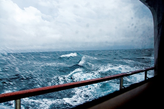
At its most pure, the appeal of long-range cruising lies in a yachtsman’s desire to challenge himself in the face of the elements, and get to where he wants to go on his own terms. The resourcefulness and creativity one finds deep within oneself seems to satisfy a need. While today’s vessels allow for comfort and relative safety, bluewater cruisers are early adopters of new technologies and use the latest tools at their disposal, but always with an eye toward redundancy.
Most ways a long-range cruiser uses new technology can be adapted to the needs of a coastal cruiser, be it keeping watch with AIS, using radar’s many tools, or tweaking engine use for optimum mileage from a tank of fuel. And as coastal cruisers adopt the techniques of their far-reaching brethren, perhaps they will be tempted to lose sight of land and push themselves a bit offshore.
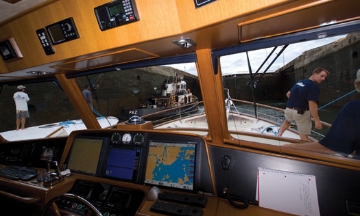
Long-range cruisers see things that most coastal cruisers only hear about in the way of speeding container ships. They like to know what they’re looking at on screen, and monitoring AIS (Automatic Identification System) lets them take back a bit of the high-seas shipping ping lanes from the big boys.
“AIS was almost critical on occasions,” says Tony Fleming, founder and president of Fleming Yachts and a globe-trotting cruiser on his Fleming 65, Venture. “This was especially so as we approached the Bay of Panama on the Pacific side at 0100. Forty ships per day transit the canal and, apart from those going to and from the West Coast of South America and Australia, the rest go around Punta Mala-Bad Point in English! Freighters these days routinely travel at 25-plus knots and we found ourselves between ships traveling at these speeds in opposite directions with a half-mile to spare on either side of us. To add to the fun, radar targets would suddenly blossom into thunderstorms. Fortunately the ships showed up on AIS with information about their size, speed and heading and it would have been a nightmare threading our way through this lot without it.”
Keep in mind, though, not every other boat at sea is equipped with AIS: “One problem is that there is a tendency to ignore other targets that are not identified with an AIS marker and one has to guard against doing this,” says Fleming.
But putting AIS on every recreational boat, an idea now under discussion, could have another effect: screens so crowded with data as to become unusable. Such cluttered harbors may be enough to send more of us offshore, where radar becomes our eyes to the horizon.
Radar is a powerful tool that becomes more useful when it’s equipped with a mini automatic radar plotting aid (MARPA). Tuning radar to keep watch for those commercial ships, and monitoring and tweaking the setup as conditions change means the helmsman will have the information on hand when it’s needed.
“As I crossed the Boston to Europe shipping channel [200 miles east of Cape Cod] it was a little stinky, rainy and foggy and all that,” says David Marlow, chairman of Marlow Yachts and a seasoned long-range cruiser on his 72-foot Marlow Explorer, Rebel Yell. “Due to the rain and fog, you had to attenuate the signal of the radar to the point where [the ship targets] would come and go. And the size of the sea would lose you or them in it-actually my boat probably, because most of the ships were much larger.”
“When I’m in the bottom of a swell and the sweep goes by you might miss a ship-for quite a while, actually,” Marlow continues. “If your course had altered in the meantime-just from yawing around-the target might appear somewhere else and it can be somewhat confusing. And when you get six or seven large ships that are well away from land and they’re at maximum speed, container vessels particularly, they’re moving pretty rapidly. Although the eastbound and westbound are constrained to a fairly narrow area, it’s still a pretty good clutter of ships.” The tracking aid gives you the information to plot your way through manually or have the machine plot your way through.
But MARPA can serve the coastal cruiser just as well.
“As we crossed from Nova Scotia to the Bay of Fundy, the place that I wanted to go to, a rock outcropping east of Maine and the Mouth of the Bay of Fundy toward Yarmouth, Nova Scotia, is a little spot called Matinicus,” says Marlow. “The approach to it has a lot of things to consider, particularly if you’re approaching in the night, which we were, at about 2:00 a.m. and the weather was foggy and rainy and sloppy. The Canadian coast guard maintains a fairly active presence there looking for poaching fishermen. There are a lot of fishermen there to boot. There are some granite rocks out there that are awful hard.”
“By having this MARPA you could target these things and it would relay their course and speed to you and you could quickly compare that to your own boat speed and course and know that a target was a boat sitting still or a rock,” says Marlow. “Whereas a boat underway, either a dragger or a military vessel, could be pretty well identified by its angle and speed and so on.”
Fleming agrees: “Being able to zero onto a ‘suspicious’ target using MARPA and to find out in short order whether we needed to be concerned about it took a lot of the stress out of watch-keeping, especially at night.” The whole idea of cruising offshore is to see things you’ve never seen before, and that novelty is at once daunting and exhilarating. But to get there, a cruiser needs to test himself and his boat’s limits.
One of the biggest limiting factors for bluewater cruisers is fuel. Calculating range, monitoring flow, and adjusting expectations are a big part of getting to the destination.
| | |
“To my mind, fuel-flow-monitoring systems are vital for serious cruising. We have MAN common-rail engines in our 65-footer. They come with fuel-flow-monitoring systems as standard,” says Fleming. “We also have Glendinning electronic controls which allow you to nudge the rpm up and down 10 rpm at the touch of a button. It is startling to see how much the fuel consumption changes even with such a small change in rpm. When traveling long distances out in the open ocean, like the 900 miles from the Galápagos to Panama, it is critical to be able to monitor fuel consumption and to be able to double check that figure with fuel actually consumed against miles covered and miles remaining.”
Tuning the engine rpm is critical to getting the most out of every gallon, and fuelflow monitors, while not always accurate, give the user access to trends in engine function that are worth watching. “It is extremely beneficial to find the so-called sweet spot that an engine has,” says Marlow. “An example might be that a turbocharged engine running at lower rpms, until it achieves a slight amount of boost from the turbocharger, doesn’t get terrific mileage. In other words, it doesn’t burn the fuel quite as efficiently as it does when it gets a little bit of boost and the engine is running cleaner and the combustion process is more complete.” Both Marlow and Fleming are also careful not to rely exclusively on electronics, and both use the sightglasses on their fuel tanks to head off any inaccuracies. They both also carry paper charts of the waters they cruise.
But if you’re going to tune the engine to that degree to squeeze all the miles out of every drop of fuel, wouldn’t it also be wise to work with the sea, rather than against it? Marlow does just that with the help of sea-surface temperature chart plotting on his journey to Halifax from Florida, using real-time images of the Gulf Stream to find agreeable plumes of current as they move up the coast.
“A straight line would carry you maybe 250 miles off the coast of the U.S. for most of the way,” says Marlow. “But the ocean currents have some benefits and if you get within a couple hundred miles of Bermuda, the net gain for that trip is pretty significant. The Gulf Stream current, as it winds its way into the North Atlantic, becomes more like a flower or a plant and on these limbs and branches and flowers, you ride one of them too far, you’ll find yourself out on a limb, literally. You have to bite the bullet occasionally and run in the counter-currents to get across from one plume to the other.”
Coastal cruisers can find fair winds and currents to optimize fuel use on travels near and far. The lessons learned on each journey make the next leg simpler and the cruiser more bold, but not foolishly so. And the tools at hand solve problems in ways that didn’t seem so obvious closer to land.