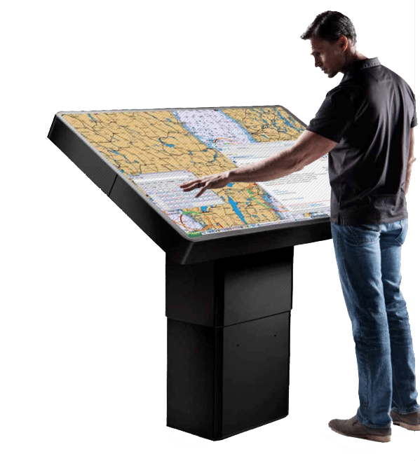
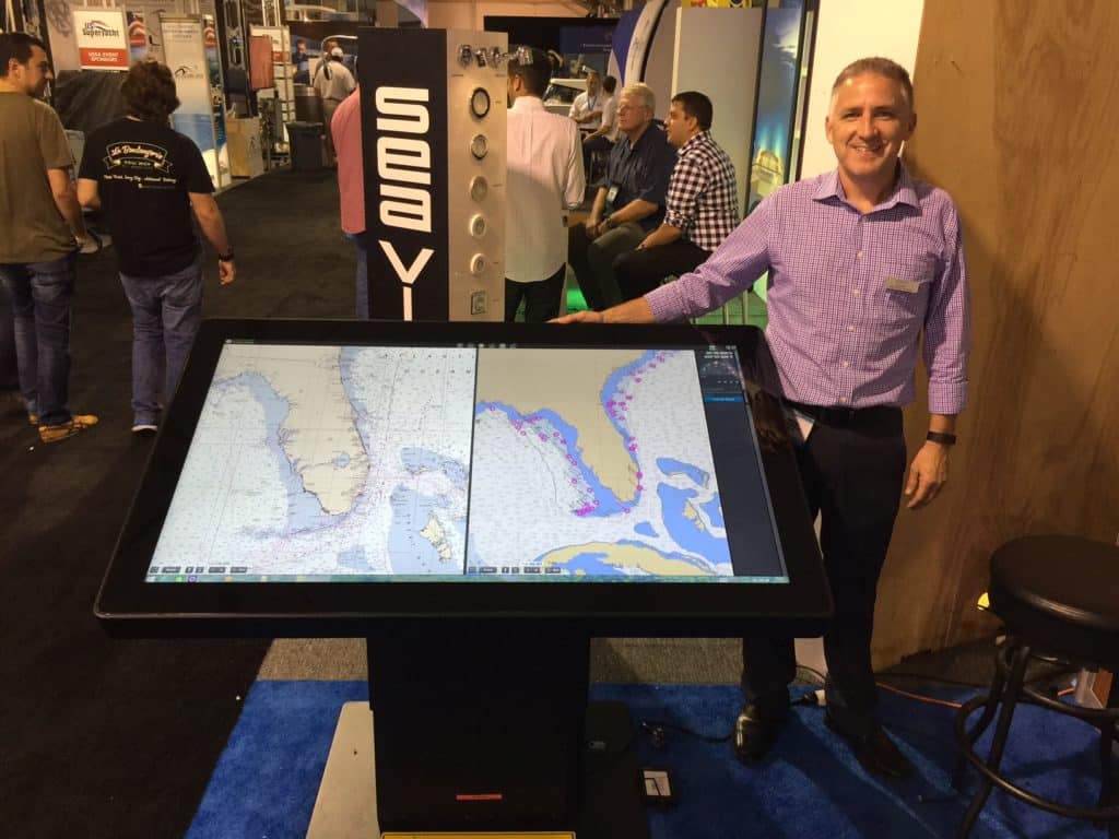
As someone who closely covers the marine-electronics market, I rarely have my shoe leather come to a screeching halt at a boat show. But I’m pretty confident that I excavated two smoking trenches in the carpet at last fall’s Fort Lauderdale International Boat Show when I spied Hatteland Display’s 55-inch digital chart table. The big-glass beauty was on an exposed corner of Hatteland’s booth, subtle like the noonday equatorial sun, and I immediately felt the display’s gravity draw my fingers to its touchscreen acreage. Other showgoers experienced similar effects. Gobsmacked superlatives aside, I couldn’t shake the notion that this table could prove an important link in advancing the electronic-cartography revolution aboard globe-girdling yachts.
Irrespective of vessel size, mariners have two options for route planning: paper charts rolled out on a table or electronic navigation charts displayed on a PC or multifunction display. Once plotted, routes from either source must be exported to the vessel’s navigation system. Large, International Maritime Organization-compliant vessels typically use paper charts and dedicated chart tables for route planning, and electronic chart display and information systems, or ECDIS, for navigation. Recreational yachtsmen can employ either planning method while relying on their MFD or PC to navigate. While this system works, paper charts can be cumbersome, and manually leapfrogging waypoints can introduce error. Also, the relatively small screens on most MFDs and PCs fall shy of the geographic awareness afforded by a full-size chart.
This is poised to change. Hatteland’s chart table combines the power of an internal PC with the flexibility of a giant monitor for any networked MFDs, thus allowing networked instrumentation to be displayed on the big glass. This gives users a huge amount of screen real estate, multiple processor options (i.e., the PC or networked MFD), seamless compatibility with the vessel’s navigation system via third-party routing software, multiple installation options, and IMO compliance for large ships (model depending).
“We think that the new 55-inch chart table is going to be excellent for trip planning,” says David Neal, Hatteland Display’s director of sales in the Americas.
The company designed a version of the table to be both ECDIS and radar compliant, then had it tested and type-approved for service aboard IMO vessels. This compliance and approval allows professional and recreational mariners alike to plan their route on the chart table and then digitally export the data. “Mariners can share the route with a program like Nobeltec and then send the [data] to their [navigational] monitors,” Neal says.
The table uses projected-capacitive, or ‘p-cap,’ touchscreen technology for its user interface.
The table uses projected-capacitive, or “p-cap,” touchscreen technology for its user interface. It has 4K resolution (VGA to UHD) and optical bonding to reduce glare, as well as a motorized pedestal that lets a user raise, lower and tilt the table to suit his ergonomics.
While the pedestal is an elegant solution for creating a one-size-fits-all table, it also houses a Hatteland HT C02 computer, which can run routing software and be upgraded as technology evolves. Hatteland included a variety of signal terminals and firmware to ensure signal agnosticism, including HDMI, DVI-D and Ethernet. This allows users to network the chart table with any peripherals that will connect to a normal monitor, either directly or via a video-switch system. (Physically connecting the table to MFDs and instruments depends on how the table is integrated, as well as what hardware and software is involved.)
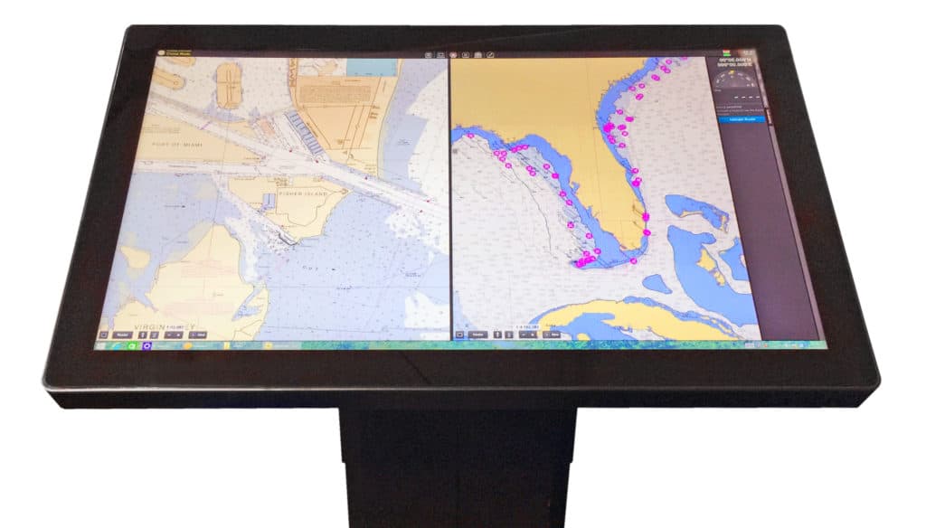
As a result of its connectivity options, the table can display imagery ranging from electronic charts, radar and sonar to movies and satellite television. The table is also capable of split-screen views, giving it the equivalent of four 27-inch screens. Graphics adapters are available that allow input signals to be displayed simultaneously and scaled to any size. This enables you to run, for example, a chart plotter with radar and AIS overlay on one part of the screen, a thermal-imaging camera on another and a forward-looking sounder on a third, reserving the final section for streaming Netflix. Also, the table has a built-in PC, and it can be simultaneously networked to a black-box MFD, so users can harness multiple processors to a single screen.
While paper charts will almost certainly be used for navigational redundancy for the foreseeable future, Hatteland’s table provides a depth of situational awareness that traditional charts simply can’t touch, especially when vector cartography, high-resolution photographs and satellite imagery are involved.
“Larger viewing room is something that everyone wants,” Neal says. “You can see so much more of the chart that it makes route planning easier and more fulfilling.”
Moreover, the table’s smooth integration with a vessel’s ECDIS or MFDs and other navigational equipment make it a strong consideration for yachts that can accommodate its size. IMO-level ships won’t toil to fit the table aboard, but midrange yachts might struggle unless the pilothouse is specifically designed around the table.
“We’re getting a lot of calls from [large] yachtbuilders, individual captains and owners,” says Neal, adding that the table will initially be targeted toward IMO ships and yachts in the 100-foot range and up. “It will depend on how much room [owners and yacht designers] are willing to make for the table. I see the demand in the early days being superyachts, but I see it coming down to smaller yachts once designers [integrate the table].”
As of this writing, Hatteland’s chart table is in the prototype stage. Neal believes it will start shipping sometime in the fourth quarter of this year.
And as impressive as this digital chart table is, it’s important to note that other manufacturers, including Palladium and Team Italia, have previously introduced large touchscreen-enabled chart tables. However, neither unit was designed or approved for ECDIS-level work aboard IMO ships, nor did either unit offer the same source agnosticism that Hatteland’s chart table provides. Moreover, Hatteland’s use of a telescoping and tilting motorized pedestal is unique, as is the table’s flexibility to be mounted on a wall, bulkhead or — if space permits — a dream console.
As for the Hatteland table’s ability to command a crowd, install one in your pilothouse and see where your nautically minded friends go to plan their next adventure.
Use a Coaster!
Unlike traditional chart tables, Hatteland’s 55-inch backlit LED table can respond simultaneously to as many as 40 touchpoints, meaning its sensitive screen needs to be treated with care. The electronic table comes with an IP66 rating for its front end (IP22 for its back end), but avoid getting salt water or other liquids on the monitor. And don’t scratch the surface. Fingerprints are inevitable, but the manufacturer suggests using a small amount of fresh water as a solvent. It can be dabbed on with a sponge and wiped clean using a microfiber cloth.